| Language: |


|
Country: |


![]()
 Germany > Hessen > Lahn-Dill-Kreis
Attention! This Geocache is "Archived"! There is no physical container at the specified (or to be determined) coordinates. In the interest of the place it should not be necessarily to search!
|
|
||||
|
|||||


 Size: large
 Status:
  Time required: 3:00 h
 Hidden on: 12 January 2015
 1 Found
 0 Not found
 0 Notes
 1 Maintenance log
 3 Watchers
 0 Ignorers
 55 Page visits
 0 Log pictures

 Cache lists
| Route |

|
| Waypoints |

|
| Time |

|
| Seasonal |

|
| Persons |

|
![]() Description
Deutsch
(German)
Description
Deutsch
(German)
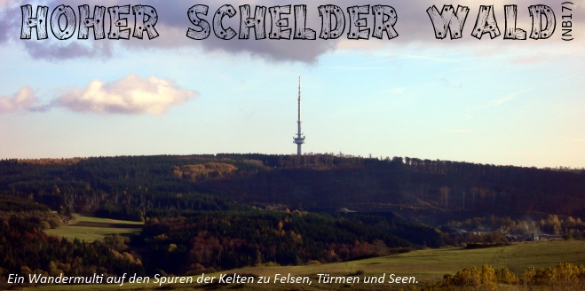
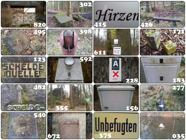
„Hoher Schelder Wald“ ist ein ca. 12km langer (Rad-) Wander-Ablesemulti zwischen der Angelburg (609m) und der Hohen Koppe (540m). Auf den historisch bedeutsamen Spuren der Kelten führt dieser inoffizielle und daher unbeschilderte Rundweg zu sehenswerten Felsen, Türmen und Seen. Der Schwerpunkt dieses Multicaches liegt auf dem (Rad-) Wandern durch schöne Waldgebiete mit tollen Aussichten und mehreren Sehenswürdigkeiten. Wanderer sollten ca. 3 Stunden Zeit einplanen, Mountainbikefahrer etwa die Hälfte. Die Wegstrecke lässt sich bei Bedarf auch gut in zwei Etappen einteilen, indem man Wegpunkt G als Endpunkt von Etappe 1 bzw. Startpunkt von Etappe 2 wählt. Für möglichst ununterbrochenen Wanderspaß sind unterwegs keine Rätsel zu lösen, sondern lediglich die Bilder den Wegpunkten zuzuordnen. Aber nur genau ein Bild ist einem Wegpunkt zuzuordnen, d.h. es bleiben 6 Bilder übrig.
N 50° 47.(A+C-E+G-I+K-M) E 8° 24.(B+D-F+H-J+L-N)
Visible Virtual Stage HA NB17A Wegpunkt A (Virtual Stage) N 50° 46.974 E 008° 24.648 Edit Map
Note:
Visible Virtual Stage HB NB17B Wegpunkt B (Virtual Stage) N 50° 46.626 E 008° 24.462 Edit Map
Note:
Visible Virtual Stage HC NB17C Wegpunkt C (Virtual Stage) N 50° 46.335 E 008° 23.716 Edit Map
Note:
Visible Virtual Stage HD NB17D Wegpunkt D (Virtual Stage) N 50° 45.983 E 008° 24.051 Edit Map
Note:
Visible Virtual Stage HE NB17E Wegpunkt E (Virtual Stage) N 50° 45.979 E 008° 24.471 Edit Map
Note:
Visible Virtual Stage HF NB17F Wegpunkt F (Virtual Stage) N 50° 46.358 E 008° 24.629 Edit Map
Note:
Visible Virtual Stage HG NB17G Wegpunkt G (Virtual Stage) N 50° 46.742 E 008° 25.116 Edit Map
Note:
Visible Virtual Stage HH NB17H Wegpunkt H (Virtual Stage) N 50° 46.769 E 008° 25.642 Edit Map
Note:
Visible Virtual Stage HI NB17I Wegpunkt I (Virtual Stage) N 50° 46.961 E 008° 25.987 Edit Map
Note:
Visible Virtual Stage HJ NB17J Wegpunkt J (Virtual Stage) N 50° 47.343 E 008° 25.813 Edit Map
Note:
Visible Virtual Stage HK NB17K Wegpunkt K (Virtual Stage) N 50° 47.585 E 008° 25.363 Edit Map
Note:
Visible Virtual Stage HL NB17L Wegpunkt L (Virtual Stage) N 50° 47.370 E 008° 24.972 Edit Map
Note:
Visible Virtual Stage HM NB17M Wegpunkt M (Virtual Stage) N 50° 47.294 E 008° 24.767 Edit Map
Note:
Visible Virtual Stage HN NB17N Wegpunkt N (Virtual Stage) N 50° 47.058 E 008° 24.670 Edit Map
Note:
Visible Parking Area PK PK Parkplatz (Parking Area) N 50° 46.988 E 008° 24.569 Edit Map
Note:
Visible Reference Point ZA NB17ZA Fotolocation (Reference Point) N 50° 46.581 E 008° 24.177 Edit Map
Note:
Visible Reference Point ZB NB17ZB Referenzpunkt von C nach D (Reference Point) N 50° 46.305 E 008° 23.867 Edit Map
Note:
Visible Reference Point ZC NB17ZC Fotolocation (Reference Point) N 50° 46.033 E 008° 24.318 Edit Map
Note:
Visible Reference Point ZD NB17ZD Fotolocation (Reference Point) N 50° 46.110 E 008° 24.468 Edit Map
Note:
Visible Reference Point ZE NB17ZE Kletterparadies (Reference Point) N 50° 46.149 E 008° 24.509 Edit Map
Note:
Visible Reference Point ZF NB17ZF Referenzpunkt von L nach M (Reference Point) N 50° 47.424 E 008° 24.811 Edit Map
Note:
![]() Additional hint
Additional hint
![]() Decrypt
Decrypt
W ,R ,P :rgxahctrJ rerupvfrraupf gupvA
553 GUPVA gfv V gxahctrJ
aurmgupn :aryonveniynavS 6 erq rzzhferhD
aravrgfzyruyvJ-vavZ ergah :gebynavS
A|B|C|D|E|F|G|H|I|J|K|L|M
N|O|P|Q|R|S|T|U|V|W|X|Y|Z
![]() Utilities
Utilities
This geocache is probably placed within the following protected areas (Info): FFH-Gebiet Schelder Wald (Info), Landschaftsschutzgebiet Lahn-Dill-Bergland (Info), Naturpark Lahn-Dill-Bergland (Info)
 Search geocaches nearby:
all -
searchable -
same type
Search geocaches nearby:
all -
searchable -
same type
 Download as file:
GPX -
LOC -
KML -
OV2 -
OVL -
TXT -
QR-Code
Download as file:
GPX -
LOC -
KML -
OV2 -
OVL -
TXT -
QR-Code
 When downloading this file, you accept our terms of use and Data license.
![]() Log entries for Hoher Schelder Wald (Wandermulti)
Log entries for Hoher Schelder Wald (Wandermulti)
![]() 1x
1x
![]() 0x
0x
![]() 0x
0x
![]() 1x
1x
 19 April 2018
mr.checkmate
has archived the cache
19 April 2018
mr.checkmate
has archived the cache
Weg damit
 26 December 2015
r.u.f.
found the geocache
26 December 2015
r.u.f.
found the geocache
Heute sind wir bei schönstem Sonnenschein durch die Schelder Wälder gewandert und haben dabei die Variablen bestimmt. Nach knapp 2,5 Stunden und 11,5 km auf dem Garmin standen wir wieder am Parkplatz.
Diese stimmige Runde in schöner Umgebung hat uns sehr gut gefallen. Es gab viel Interessantes zu sehen.
DFDC und Grüße aus Siegen......................................r.u.f.