| Taal: |


|
Land: |


- Hoofdmenu
- Zoeken
- Maak een cache
- Beschrijving
- Toegestane HTML Tags
- My caches
- Bijzondere Caches
- Cache lists
- OConly-81


Gabriach
Short multi-cache along paths, approx. 20-30 minutes.
door aj-gps
 Oostenrijk > Steiermark > Graz
|
|
||||
|
|||||


 Grootte: klein
 Status: Beschikbaar
 Benodigde tijd: 0:30 h
 Verborgen op: 04. juli 2007
 Ook gepubliceerd op:
  24 Gevonden
 1 Niet gevonden
 1 Opmerking
 1 Watcher
 0 Negeerders
 161 Bekeken
 0 Log pictures

![]() Beschrijving
Deutsch
· English
(Engels)
Beschrijving
Deutsch
· English
(Engels)
This short multi-cache, which will take approximately 20-30 minutes, will lead you to the church of St. Veit, part of the district Andritz, north of Graz. The church itself is located on a hill, just high enough to offer a view over the city.
It is not recommended to visit this cache at night as some parts of this cache and the final location are located at places where the use of flashlights might either not be appropiate or arouse suspicion.
It's not necessary to enter the coordinates of all the stages into the gps-receiver - most can be found by just following the description. Just in case coordinates are still supplied.
Note: One stage is located on a graveyard. It is just a question to answer and I recommend to act appropiately and put away the gps-r. Relatives of mine found their last home there, so ...
Information found in this description is based on various on- and offline sources. Most should be reliable, but I can't guarantee their validity.
Approach
Car: I'd recommend to leave your car along the street where the parking coordinates - waypoint PARK, N47 06.817 E015 24.835 - are pointing to. There are some places around stage 1 where one could leave a car, but they are all marked as private property.
Bike: Take bike-way R2 north along the left (east) side of the river "Mur". If you approach from south you will pass a big DIY store ("Baumax"). Shortly afterwards - at waypoint BIKE, N47 06.434 E015 24.689 - turn right onto a small unpaved path. You will then drive along the so-called "Kirschenallee" (which basically translates to "cherry tree avenue") and pass some public sports grounds. Follow the path which then turns into a small paved road until you reach a street crossing. There turn right for a few meters, then left. Continue and you'll arrive at stage 1. You can then either continue by bike or leave it there.
Public transport: Take GVB bus #53 ("Hauptbahnhof-Stattegg/Fuss der Leber") and leave at station "St. Veit" (after "St. Gotthard"). This bus line also passes by the station "Andritz" which can be reached by GVB tram lines 4 and 5 and bus-lines 41 and 52. Bus/Tram-timetable available here.
Name
The settlement around the church used to be called "Gabriach", stemming from the Slavic word "gaber" which means hornbeam tree ("Weissbuche"). Today the nearby creek named "Gabriachbach" still refers to that name.
The hill of todays St. Veit used to be called "Am Aigen", which basically translates to "free property" - contrary to the back-then common fiefdom. Today a nearby street still reminds of that name.
By 1850 the municipality of "St. Veit ob Graz" was created. 1938, when todays district Andritz was annexed by Graz, the area became a part of Andritz, todays Graz' 12th district.
History
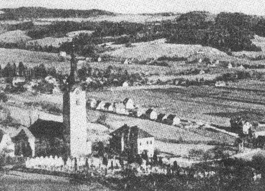
In the early middle ages the hill of (now) St. Veit used to be the base for an escape castle. Later on fortified defence towers were built, where people found shelter during the Hungarian invasion. The wooden walls were then replaced with stone and a nave was built, first referenced in books by 1226.
In the 17th century todays church, designed by the Italian builder Domenico Sciassia (died in Graz February 19th, 1679) who also extended the Basilica of Mariazell (1644-1683), was built. He also built the chapel at the nearby castle St. Gotthard, but this chapel was teared down in 1808.
Works on the building in St. Veit finished 1662 and 1680 a baroque high altar was created by Hans Adam Weißenkirchner, painter at Eggenberg, donated by prince Seyfried of Eggenberg. In 1713 the churchtower was built (re-built in 1951).
By 1780 children were educated in a room of a tavern next to the church. 1901 todays' school was built.
1906 the first power lines were laid and electric light could be used.
Stage 1: chapel
At stage 1 - N47 06.854 E015 24.798 - you'll find a small chapel, a reminder for the times when Pest plagued the residents.
Nearby there are two direction signs, a green one below a white one.
A = number of graphical symbols on the second sign (the green one) excluding the arrow
B = number of letters of the last word of the inscription of the chapel (6 words)
Note: The inscription was overpainted during the last renovation works. You will find an older picture of the chapel on a sign nearby where you can spot the old inscription.
Now follow the street uphill.
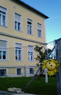
| Stage 2: the school The first building to your right is the school of St. Veit. In Winter the slope below the gym hall is a very popular place for luging. N47 06.919 E015 24.731 A work of art by small artists, Natalie and others. C = last digit of the year, 200x Now continue uphill until you reach a street to your left. |
 |
Stage 3: memorial of war
N 47° 06.934 E 015° 24.704
D = Nearly the last digit of the date: 1860 19x5
If you came by bike leave it there, we'll pick it up later.
Now take the street to your left, and walk along until you reach a parking lot. While walking there have a look at the city to your left.
 |
Stage 4: a warning N47 06.930 E015 24.624 At the right side of the parking lot near the path to the church you'll find a sign with a red edge. E = Number of question marks on the sign (0? E=0; 1? E=1; 2? E=2, 3? E=3, ..) Now continue to the church, but please put away your gps-r first. It's a graveyard, not your playground. Stage 5: cross No coordinates are given for this stage (for obvious reasons). The target is a (really) large wooden cross on the South side of the church building. F = second digit on the cross Now continue around the church until you reach some stairs leading to the street below. Right next to the stairs there is a wooden door which leads onto the concrete archway that you might have spotted from stage 3 and to the parsonage. I am not sure if entering the archway is allowed though, so we just walk down the stairs. If you left your bike at stage 3 go down the few meters and fetch it, then come back up here. Then continue on the street that's straight ahead until you reach a gravel road that leads downhill to your right. |
Stage 6: famous guy
One of the best-known people in St. Veit was Lois Steiner (1907-1989), who used to be headmaster of the nearby school and is known for collecting Styrian folk songs.
You should now be close to a street carrying his name.
N47 07.035 E015 24.719
Here are two round signs with red edges on the same pole.
G = Twice the first digit of the sign that contains two digits. (The result is a single digit!)
If one would continue walking on the same street one would reach the post office of 8046 St. Veit, which was abandoned in June 2002. It looks like it was frozen in time, there are still advertisements from 2002 on its door..
Now take the gravel road downhill towards the "Gabriachbach".
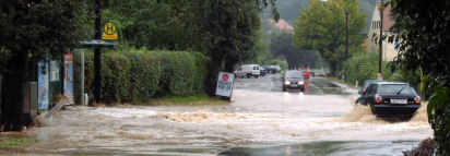
This creek has it's source north of the church of St. Veit and flows into the "Andritzbach" near the B67a (bikeway R2). Parts of the flow of this creek are then used on the area of the cities northern waterworks (right across the street of waypoint BIKE) for artificial groundwater recharging purposes. The creek then flows into the river "Mur".
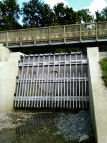
Below you'll see a more or less interesting construction - a retention pond for 26.200 cubic meters of water. It was recently built together with other installations at a cost of 2 billion euro in a response to the flooding that occured on August 21st, 2005, that devastated nearby basements and great parts of the allotment garden south-west of the parking coordinates. A picture timeline of its construction is available here.
Stage 7: Nice place
N47 06.994 E015 25.054
You have arrived at a rather nice place which used to be the final location for this cache for more than 10 years. During this time the area became a playground and the container went missing a few times.
Because of that you now have to answer a rather boring question:
H=What do you see?
2 - a yellow boundary stone
4 - a red warning sign
8 - a green birdhouse
By now you should already have all the necessary values for calculating the location of the final stage, the cache box.
N47 0(D-1).A(H+E)F E015 2C.E(C+G)(B+H) (no multiplications!)
The cache is covered with pieces of bark.
Way back: Follow the gravel road near Stage 7 south towards Stage 1.
HAVE FUN!
![]() Gecodeerde hint
Gecodeerde hint
![]() Decoderen
Decoderen
Gerr fghzc ng n qvfgnapr bs 2z gb n ovepu gerr, 3z gb n znexrq obhaqnel fgbar.
A|B|C|D|E|F|G|H|I|J|K|L|M
N|O|P|Q|R|S|T|U|V|W|X|Y|Z
![]() Hulpmiddelen
Hulpmiddelen
 Zoek caches in de omgeving:
alle -
zoekbaar -
zelfde cache soort
Zoek caches in de omgeving:
alle -
zoekbaar -
zelfde cache soort
 Download als bestand:
GPX -
LOC -
KML -
OV2 -
OVL -
TXT -
QR-Code
Download als bestand:
GPX -
LOC -
KML -
OV2 -
OVL -
TXT -
QR-Code
 When downloading this file, you accept our terms of use and Data license.
![]() Logs van Gabriach
Logs van Gabriach
![]() 24x
24x
![]() 1x
1x
![]() 1x
1x

 02. januari 2023
Zoidberg73
heeft de cache gevonden
02. januari 2023
Zoidberg73
heeft de cache gevonden
Ein nachmittäglicher Ausflug Richtung Andritz brachte Pimi1 und mich nebst einigen schönen Spaziergängen auch an so manchen Dosen vorbei...
Anmerkung zu diesem Cache: Diese Runde hat uns gut gefallen; die Hintergrundinformationen bei den einzelnen Stationen sowie Themen und Wegführungen zeigen hier einen richtig gut gemachten Multi aus den alten Tagen... nicht umsonst ist er nach so vielen Jahren weiterhin aktiv und "gut in Schuß". Die Informationen konnten problemlos ermittelt werden und am GZ war der Dosenfund eine klare Angelegenheit.
TFTC an aj-gps für Idee, Realisierung und Wartung dieses Caches!
31. juli 2019
Jacky81
heeft de cache gevonden
Schade das dass Final so entfernt von der Kirche liegt  Hätte bei der Kirche sicher besser gepasst
24. mei 2014
run-cache-run
heeft de cache gevonden
Anfangs war es relativ leicht, die Stationen zu finden, dann habe ich eine übersehen und bei der übernächsten kam dann ein anderer Cacher des Weges. So verglichen wir unsere Stationen, rechneten und gingen gemeinsam zum Final, was dann rasch gefunden war.
TFTC!
19. april 2012
a fluke
heeft de cache gevonden
sehr netter und durchdachter multi besonders die finallocation hat mir gut gefallen
das
bacherl kam gerade recht um die schuhe von der hundekacke zu befreien
in die ich beim suchen von St.Veiter Kirche getreten bin ...
lediglich
das kunstwerk der kleinen künstler konnte ich nicht ausfindig machen,
da dort gerade gebaut wurde und ich nicht richtig herumsuchen wollte...
der cache war aber auch ohne diese variable ausfindig zu machen
danke vielmals fürs verstecken
03. september 2011
helilen
heeft de cache gevonden
In: Fisch
Out: Murmel
TFTC