| Langue : |


|
Pays : |


| Suivez-nous : | |||
| Contact us: | |
| Rejoignez les discussions : | ||||
|
|
Forum d'Opencaching | |||

|
Groupe Facebook | |||

|
GitHub | |||

|
Slack | |||

![]()
 Allemagne > Nordrhein-Westfalen > Euskirchen
Attention ! Cette géocache est "archivé"! Il n'y a pas une conteneur physique aux coordonnées spécifiées (ou déterminées). Dans l'intérêt de l'endroit il ne devrait pas être nécessairement à la recherche !
|
|
||||
|
|||||


 Taille : normal
 Statut :
  Temps nécessaire : 2:30 h
 Caché en : 12. septembre 2007
 Aussi listé au :
  24 trouvé
 4 pas trouvé
 0 Remarques
 1 Log maintenance
 8 Observateurs
 0 Ignoré
 514 Visites de la page
 7
7 

![]() Description
Deutsch
· English
(Anglais)
Description
Deutsch
· English
(Anglais)
VEYBACHTAL MULTI
CHALLENGE
This cache leads you directly into an environment where verifiably 10,000 years ago
people lived. In 1971 archeologists found remains of tools from the Old Stone Age, and
also bones of mammoth, wool rhinoceros, reindeer and giant deer. Later this area was
used as stone pit by the Romans between the 1st and 3rd century a. D. Marks of the
exploitation can still be seen on the south and east side. About 200 meters east of the
rocks remains of the Roman aqueduct to Cologne can still be seen. In the summer months
the area is a popular meeting place for free climbers.
During the search on this terrain which is partially not easy, altogether ten aluminum
badges (diameter 30 mm) have to be traced in order to get to the cache.
The complete distance of the course is less than 1,000 meters beeline, but for a
successful search you should better include two or three hours.
Please note!
All badges are fixed in places where nobody has to risk their lives!!!
But solid footgear is absolutely necessary, so is dry weather and daylight!!!
Explicit advice:
This area is not suitable for little children!!!
Example for a aluminum badge:
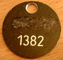
Example for the calculation:
Supposing that the badge above is “X”.
Then isX1= 1 | X2= 3 | X3= 8 | X4= 2
Here we go:
Immediately at the given starting point/parking lot you find the first badge (=A!), which is attached somewhere at an illustrated chart. Please keep the grade of difficulty always in mind! Fair hiding-places are not to be expected neither here nor for the other nine badges.For all coordinates goes: N 50°36. + + + / E 006°41. + + +
Now go on to:
(A1)81 / (A3)34
The next 8 badges (B – I) can all be found in the near environment. Due to the bad reception here, the positions can only be found with the help of the photos, which should certainly be printed and taken along.
Caution!! Especially the grade of difficulty concerning station F should not be underestimated. If you are not sure here how to get to the badge, you better take a look at the bonus hint in the nearby VEYBACHTAL TRADITIONAL at 185/410. The four-digit figure can be found there in the cache box if necessary.
While looking for badge “G”, a torch might be helpful.
Immediately next to badge “I”, you can see the traces of the stone exploitation of the Romans in good condition.
At
(D4-H4)(F4+G2)(I3-B2) / (C4-D2)(E2-C3)(H2-E4)
there is one more badge, (=J!), before the cache can be retrieved. There is no photo available. Small hint: “J” is placed at a tree stump.
The cache is hidden at:
(B4+J1-E3)(J2+G4-B3)(H3+A2-I1) / (F2+G3-B1)(D3-C1-A2)(J3-I4+D1)
Have fun!!
![]() Indice additionnels
Indice additionnels
![]() Déchiffrer
Déchiffrer
Nqqvgvbany uvag: Abgr gur FCBVYRE!!!
A|B|C|D|E|F|G|H|I|J|K|L|M
N|O|P|Q|R|S|T|U|V|W|X|Y|Z
![]() Images
Images
![]() Utilités
Utilités
Cette géocache est probablement placé dans les zones de protection suivantes (Info) : Landschaftsschutzgebiet LSG-Kreis Euskirchen <Teilflaeche 1> (Infos), Naturpark Hohes Venn (Nordeifel) (Infos)
 Montrer les recommandations de cache des utilisateurs qui ont recommandé ce géocache : tout
 Chercher des géocaches prés:
tous -
trouvable -
même type
Chercher des géocaches prés:
tous -
trouvable -
même type
 Télécharger en fichier :
GPX -
LOC -
KML -
OV2 -
OVL -
TXT -
QR-Code
Télécharger en fichier :
GPX -
LOC -
KML -
OV2 -
OVL -
TXT -
QR-Code
 Lors du téléchargement de ce fichier, vous acceptez nos conditions d'utilisation et la licence de données.
![]() Logs pour VEYBACHTAL MULTI CHALLENGE
Logs pour VEYBACHTAL MULTI CHALLENGE
![]() 24x
24x
![]() 4x
4x
![]() 0x
0x
![]() 1x
1x

 06. août 2015
mic@
a archivé la géocache
06. août 2015
mic@
a archivé la géocache
Das letzte Funddatum liegt lange zurück und das Vorlog läßt darauf schließen, das der Cache wegen fehlender Plaketten nicht mehr zu finden ist. Aus diesem Grunde archiviere ich ihn auch hier. Sollten sich später neue Aspekte ergeben, so kann dieses Listing durch den Owner selbständig über ein "kann gesucht werden"-Log reaktiviert werden.
mic@ (OC-Support)
 12. juillet 2015
Himpel u. Frosch
n'a pas trouvé le géoacache
12. juillet 2015
Himpel u. Frosch
n'a pas trouvé le géoacache
Schade, das klang sehr spannend, aber dieser Cache scheint nicht mehr aktiv zu sein! Wir haben zwar die Katzensteine gefunden, aber keine einzige Plakette mehr, wurden sie abmontiert?
Himpel u. Frosch mit Eltern

 27. mai 2012
Selvaggio
trouvé la géocache
27. mai 2012
Selvaggio
trouvé la géocache
Die Katzensteine sind ein echt toller Spielplatz für die Großen. Ganz mein Ding! Es machte richtig Laune, die Plaketten zu finden, und die Erfolge stellten sich -bis auf einen kleinen Hänger bei E- auch schnell ein.
Ohne Einschränkungen ist das ein wahrer Spitzenklasse-Multi, der in meiner persönlichen Rangliste ganz weit oben rangiert. Respekt und Dank an den Owner!
Gruß,
Selvaggio
in: FAV-Point & 5 Punkte bei GCVote
out: nix
18. mars 2012
kaktuskoeln
trouvé la géocache
Sodele... geht doch. Nachdem sich uns J gestern nicht zeigen wollte, ging es heute nach Bestätigung des Vorhandenseins durch Rocket013 (Vielen Dank!) ganz fix und auch der Final fand sich ohne Probleme. Da hatten wir gestern wohl massiv Tomaten auf den Auge, vielleicht auch dadurch gefördert, dass wir damit rechnen mussten, vielleicht gar nicht am rechten Ort zu sein.
Aber Spaß hat's gemacht... solche Suchspielchen mit Bildern in einem interessanten Gelände mag ich.
Raus: Nix
Rein: Favoritenpunkt ![]()
TFTC
kaktuskoeln
This entry was edited by kaktuskoeln on Sunday, 18 March 2012 at 21:12:15 UTC.
kaktuskoeln vor der Windrose

17. mars 2012
kaktuskoeln
n'a pas trouvé le géoacache
Hmmm, irgendwie klappt's nicht. ![]()
Wir (Andarius und ich) waren heute noch mal an den Katzensteinen, haben recht fix die beiden uns noch fehlenden Plaketten gefunden und Plakette C noch einmal nachgesehen: Die ist nach wie vor genau dort, wo wir sie schon am 14. Januar gefunden hatten (siehe Andarius' Note) und hat auch noch genau dieselbe Zahl.
Ob und wenn ja, warum die Plakette C erneuert wurde, erschloss sich uns nicht so ganz. Wir haben dann jedenfalls die Position von J ausgerechnet und an den betreffenden Koordinaten einen Platz gefunden, der eigentlich recht passend erschien. Nur eine Plakette haben wir dort trotz langer und eigentlich auch recht intensiver Suche nicht gefunden.
Wir sind dann sicherheitshalber noch mal zu C, um nachzusehen, ob da womöglich eine zweite Plakette mit einer anderen Zahl verlegt wurde, haben aber nichts gefunden.
Ich glaube, bevor wir das nächste Mal hinfahren, brauche ich ein wenig Trost und Zuspruch vom Owner. ![]()
Gruß,
kaktuskoeln