| Idioma: |


|
País: |


 Alemania > Bayern > Tirschenreuth
|
|
||||
|
|||||


 Tamaño: sin contenedor
 Estado: disponible
 Tiempo requerido: 2:00 h
 Ocultos en: 26. junio 2008
 También en la categoría de:
  13 encuentran
 0 no encontrado
 0 Notas
 4 Observado
 2 Ignorado
 609 Visitas
 3
3 

| Ruta |

|
| Waypoints |

|
![]() Descripción
Deutsch
(Alemán)
Descripción
Deutsch
(Alemán)
the Waldnaab valley
The wild and romantic nature reserve Waldnaabtal, which takes up 180 hectares, reaches from Falkenberg to Windischeschenbach. The river bed with its many alders is edged by quaint granite rocks, reaching up to 30 meters high. Due to several hiking trails, the area is easily accessible and a textbook example for the effects of exogenous forces on granite.
The Waldnaab valley is a station of the “GEO-TOUR Granite”, which was founded by the Geocentre Windischeschenbach in cooperation with the Bavarian state office for geology. The valley will also been added to the list of Bavarian’s 100 most beautiful geotops (Geotop-Nr. 377R013).

source: GEOPARK Bayern
Geological information
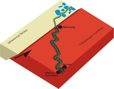
The Waldnaabtal is a valley that, at 12 km length and similar to a canon, ranges the plateau of granite surrounding the Falkenberg. By cutting into the ground quite like a saw blade, the Waldnaab manages to balance the elevation of the Falkenberg block; preferably following the loose areas of the granite, such as the subverted ones. Hence, the partly right-angled course of the river can be explained (see image).
source: GEOPARK Bayern
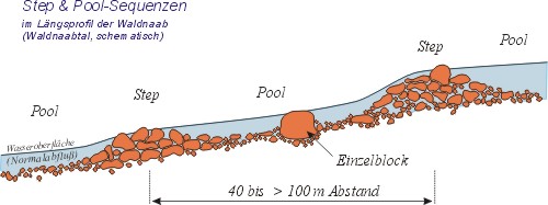
Step & Pool sequences
The repetitive sequences of rock agglomerations and mostly unblocked parts of a river are called step and pool sequences. They are a natural phenomenon in any flowing waters carrying rock like material. With their help, the river can regulate its flow on its own.
source: GEOPARK Bayern
The hike
Park at one of the many hiking trail parking lots, such as at one of the following:
| P1 | N49 51.382 E12 10.437 |
| P2 | N49 51.496 E12 12.750 |
| P3 | N49 50.414 E12 10.827 |
| P4 | N49 48.687 E12 10.080 |
Start your hike to the following 7 waypoints:
| WP1 | N49 51.230 E12 11.778 |
| WP2 | N49 51.131 E12 11.477 |
| WP3 | N49 50.946 E12 11.354 |
| WP4 | N49 50.577 E12 11.342 |
| WP5 | N49 49.844 E12 11.414 |
| WP6 | N49 49.707 E12 11.356 |
| WP7 | N49 49.493 E12 11.652 |
Depending on where you start and which route you take, the way is between 10 and 20 kilometers long. You can also reach every stop with your bike – preferably a mountain-bike.
The different stops
During your hike you will pass all of the stops listed below: they are worth seeing and given in random order. Write down at which waypoint you saw what, and remember the solutions for the bonus tasks. Don’t forget to take the pictures that two of the stops will ask you to!
Picture A - "Butter tub" (Butterfass)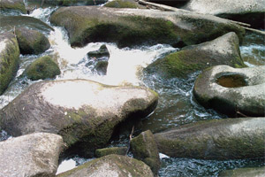 A kolk (also known as colc) is an underwater vortex that is created when rapidly rushing water passes an underwater obstacle in boundary areas of high shear. High velocity gradients produce a violently rotating column of water, similar to a tornado. Kolks are capable of plucking multi-ton blocks of rock and transporting them in suspension for some thousands of meters. Note down the number of the steps in the rock! |
Picture B - "Anvil" (Amboss)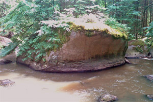 This protruding rock of granite is a textbook example for fluvial cuts. Take a picture of you and your GPS in front of the rock! |
Picture C - "Tablestone" (Tischstein)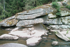 It is said that at the beginning of the 19th century the passing Napoleonic troops tried to pull the top down by using 120 horses. They were, however, unsuccessful. Don’t forget to take a picture of you and this rock! |
Picture D - "Packed wagon" (Kammerwagen)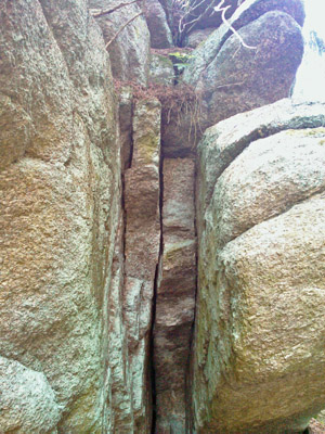 The square rocks and the entire structure resemble a greatly packed wagon. Therefore, in former times the second “wagon” was called “wedding procession”, carrying the bride’s endowment in big chests. |
Picture E - "Glacial mill" (Gletschermühle) An impressive example for the eroding qualities of water. The name is confusing, for this hole has nothing to do with glaciers. But the similarity with alpine glacial mills is striking. Remember the diameter of the hole! |
Picture F - "Memorial stone" (Gedenkstein)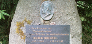 This memorial stone is dedicated to Ferdinand Windschiegl, the „father of the Waldnaab“. Note the date of the erection! |
Picture G - "Acid well" (Sauerbrunnen)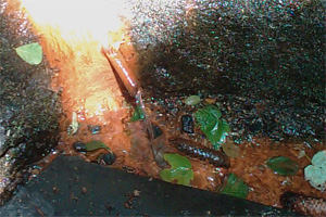 The rosset color that can be seen on the rock results from precipitated iron minerals. Carbonic acid from the water rises, and, on its way, solves many minerals, such as iron. |
The tasks:
- - Assign the correct pictures to the waypoints WP1 to WP7.
- - Which diameter does the hole of the glacial mill (Gletschermühle) have?
- - How many steps lead up to the Butter tub (Butterfass)?
- - (additional logging requirement on voluntary basis) Publish, along with your log entry, the photos that depict you and your GPS in front of the table stone (Tischstein) and the anvil (Amboss).
Please email me the answers using my geocaching.com-profile or fill in the online form on our homepage.
Log entries which do not fulfill the required tasks will be deleted!
Further links:
Bavarian – Bohemian Geopark – Europe’s geological center
http://www.geopark-bayern.de/Public/GeoTourGranit/Waldnaabtal.htm
Friends of mineralogy and geology in Weiden
http://www.vfmg-weiden.de/min.htm
Waldnaabtal in Wikipedia
http://de.wikipedia.org/wiki/Waldnaab
![]() A German version of this text is available on our homepage! - Auf unserer Homepage gibt es diesen Text auch auf Deutsch!
A German version of this text is available on our homepage! - Auf unserer Homepage gibt es diesen Text auch auf Deutsch!
Viel Spass beim Suchen!
Happy caching!
reindeer ![]()

![]() Imagenes
Imagenes
![]() Utilidades
Utilidades
![]() ¡Este geocache está probablemente situado dentro de una zona de protección de la naturaleza! Mira aqui para obtener más información, por favor.
¡Este geocache está probablemente situado dentro de una zona de protección de la naturaleza! Mira aqui para obtener más información, por favor.
Naturschutzgebiet
Waldnaabtal (Información)
Este geocache está probablemente en las siguientes áreas protegidas (Info): FFH-Gebiet Waldnaabtal zwischen Tirschenreuth und Windisch-Eschenbach (Información)
 Buscar geocaches en las inmediaciones:
todo -
búsqueda -
mismo tipo
Buscar geocaches en las inmediaciones:
todo -
búsqueda -
mismo tipo
 Descargar como archivo:
GPX -
LOC -
KML -
OV2 -
OVL -
TXT -
QR-Code
Descargar como archivo:
GPX -
LOC -
KML -
OV2 -
OVL -
TXT -
QR-Code
 Al descargar este archivo, aceptas nuestros terminos de uso y Licencia de Datos.
![]() Log de entrada por Waldnaabtal
Log de entrada por Waldnaabtal
![]() 13x
13x
![]() 0x
0x
![]() 0x
0x
 22. abril 2022
SDBH-R
ha encontrado el geocache
22. abril 2022
SDBH-R
ha encontrado el geocache
Ein Ausflug hat uns heute hierher ins Waldnaabtal geführt. Das ist wirklich eine fantastische Flusslandschaft mit ihren vielen Felsformationen und hat einen Earthcache absolut verdient. Wir sind vom Wanderparkplatz Blockhütte einmal den Fluss entlang bis zum nördlichsten Punkt gewandert, sind dort umgekehrt und haben und dann zur Halbzeit im Biergarten der Blockhütte ein tolles Essen genossen. Anschließend haben wir auf dem idyllischen Uferweg den südlichen Teil in Angriff genommen. Hier hat uns zwischenzeitlich ein alter Wegweiser zur Gletschermühle kurz irritiert, der ein klein wenig suggerierte, dass die Gletschermühle auf der rechten Seite des Flusses sei. Wir haben dann aber den Wegpunktkoordinaten vertraut und auf dem Weg auf der anderen Flussseite alle übrigen Punkte gefunden. Alle Fragen und Aufgaben waren völlig problemlos zu erledigen und vom Owner haben wir auch blitzschnell die Bestätigung bekommen. Eine wunderbare Wanderung in einer tollen Gegend, hat uns sehr gut gefallen. Das ist uns auch einen Favoritenpunkt wert.
Danke für den Cache und viele Grüße nach Pocking!
23. junio 2021
Eiertante117
ha encontrado el geocache
Auf meiner heutigen Runde konnte nach den Labcaches auch noch dieser tolle Earthcache abgearbeitet werden.
Ich bin zwar kein Freund von Earthcaches, aber dieser gefiel mir sehr gut.
Keine doofen Fragen von denen ich nix verstehe und kein Fingernageltest oder sonstiger Quatsch. Einfach gehaltene Fragen die eine trotzdem das Wesentliche zeigen. So gefällt mir das.
Vielen Dank für's Ausarbeiten und schöne Grüße an die Owner
PS:Der Käsekuchen in der Blockhütte ist sehr zu empfehlen.
Hier lasse gerne ein 💝
22. junio 2020
danspataru
ha encontrado el geocache
So ein schönes Tal. Gleich am frühen Morgen war ich hier. Eine ganz besondere Stimmung herrschte im Tal. Alle Stationen konnten recht schnell gefunden werden. Ich war ja auch mit dem Fahrrad unterwegs. Ich danke für den sehr interessanten und lehrreichen EarthCache!
22. septiembre 2019
DerBimi
ha encontrado el geocache
An diesem wunderbaren Spätsommertag zog es uns ins entfernte Waldnaabtal, in dem wir die herrliche Natur mit ihren zahlreichen Sehenswürdigkeiten ausgiebig genossen haben. Natürlich haben wir bei unserer Familienwanderung auch die Wegpunkte dieses Earth Caches besucht. Wir hatten einen wirklich tollen Tag, an dem alle auf ihre Kosten kamen, und bedanken uns fürs Herführen und Zeigen dieses urigen Tals. An einer der Stationen ist uns vor lauter Begeisterung wohl ein blauer Stein ins Wasser gefallen.
02. noviembre 2018
dreckbolla
ha encontrado el geocache
Bereits unter gc.com am 2.11.2018 geloggt:
Am Freitagnachmittag machten wir uns noch auf, mal wieder ins Waldnaabtaal zu lafuen. Junior war dabei, Mama und seine Patentante. Endlich Zeit, um diesen EC zu lösen. Bereits seit mehr als 35 Jahren ist für mich das Waldnaabtal immer wieder Anlaufstelle und Entschleunigungsmittel. Einige der tollsten Orte in diesem Naturschutzgebiet zeigt allen cachenden Besuchern dieser Earthcache.
Ich kann nicht anders, als hier ein weiteres blaues Herz dran zu heften.
Vielen Dank fürs Ausdenken, Zeigen und Pflegen dieses Caches. Hat uns sehr gefreut, ihn hier (be-)suchen zu dürfen.
dreckbolla #2382 #1.021/2018 #08/November
Freitag 2. November 2018 - Allerseelen