| Language: |


|
Country: |


![]()
Der Pfahl in der Buchberger Leite
The geotope Bavarian Forest
by Schweinebagger
 Germany > Bayern > Freyung-Grafenau
Attention! This Geocache is "Archived"! There is no physical container at the specified (or to be determined) coordinates. In the interest of the place it should not be necessarily to search!
|
|
||||
|
|||||


 Size: no container
 Status:
  Hidden on: 13 August 2009
 Also listed at:
  6 Found
 0 Not found
 0 Notes
 0 Watchers
 1 Ignorers
 260 Page visits
 3
3 

| Route |

|
| Time |

|
| Seasonal |

|
| Preparation needed |

|
![]() Description
Deutsch
· English
Description
Deutsch
· English
The Pfahls in the Buchberger Leite
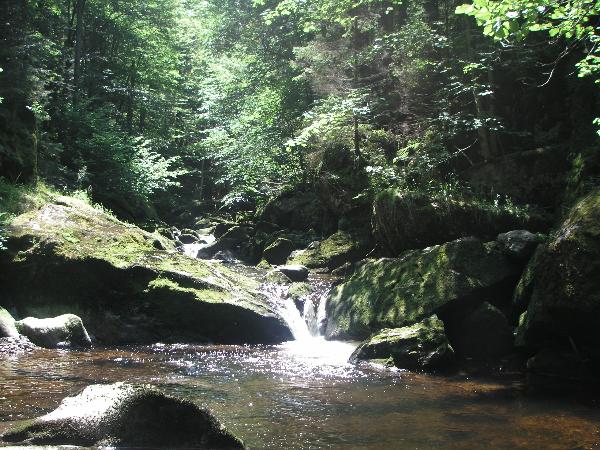
Buchberger Leite
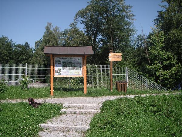
The geotope is part of the "Bavarian Pfahls, a fault zone in the Earth's crust, the Bavarian Forest close to a straight line intersects. Due to strong crustal movements along this fault line the rocks profound changes. In Buchberger Leite formed as a rock, the so-called post-Mylonit ( "pile-slate"). This is here in its various forms of training to find. The geotope is part of the 8-km( 5 miles) issues between Buchberger Leite and Freyung Ringelai and is signposted. For this trail you will take about three hours walking time, and sturdy shoes. A puplic transporation back to the starting point is available form both places. Directions - How to find the Buchberger Leite Leave the motorway A3 Regensburg and Passau on the exit Hengersberg (111) and follow the B533 from Hengersberg to Freyung. Parking Here you can find a parking zone N 48 48.527 E 13 32.299
Am Parkplatz
What is the Bavarian Pfahl zone?
The pile is a distinct zone, about 275 million years old fault zone in the Earth's crust, from southeast to northwest at a length of 150 km almost a straight line intersects the Bavarian forest. At their front was the whole Bavarian Forest to the Bavarian forest interior by several hundred meters lifted. This came after the largest movements of variceal mountain education. Through the multiple movements along this fault line the rocks profound changes. Thus the original gneisses and granites destructed and crushed. Through the pressure and temperature rise to the so-called post-Mylonit was made visible through the erosion of labor Wolfsteiner Ohe, which evolved over the millennia, some 100 m deep into the subsoil has incised. Elsewhere are some of several 100 m long and up to thirty-meter-high stone walls, piles of white quartz, visible traces of this fault zone. The quartz was formed about 250 million years - so much later than the post-Mylonite - than the post elongation zone of cracks has been crossed. Circulating, hot solutions, in addition to rock silica (SiO2) were solved, could penetrate into the cracks and is milk-whight to light-gray quartz to settle. The surrounding, softer post-Mylonite were later removed by erosion more of weathering-resistant quartz remained as a pile marked "Devils Wall" received. A particularly impressive example is the "post at Viechtach". GC1G4MH
Harness and protection in the Buchberger Leite
Since lready 1904 hydropower is created Saußbach, Resch Bach and Wolfsteiner Ohe for power generation. Two reservoirs at Sausses and Resch Bach were created therefore. The widely branched, underground and surface mines and canal still supplies the turbines of the "Carbidwerkes". The river gorge "Buchberger Leite was already 1961 under protection.
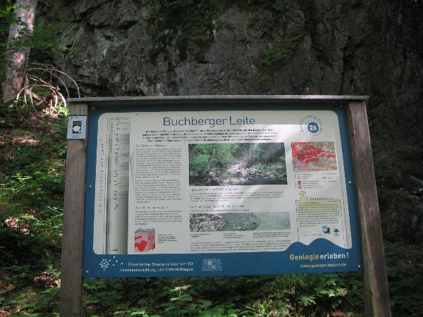
Informationstafel
Logbedingungen
Take a picture from you and your GPS device the information board (N 48 49,243 E 13 30,781), which is in the direction of the rock and add it with your Sign On. Answer the following question and send us the answer in a mail on Geocaching.com: Which place is the highest post and what he achieved there? If your logs did not fulfill these conditions, we delete it, unfortunately.
PS: This cache can be well combined with GC19VEN.
![]() Utilities
Utilities
This geocache is probably placed within the following protected areas (Info): FFH-Gebiet Ilz-Talsystem (Info), Landschaftsschutzgebiet LSG "Bayerischer Wald" (Info)
 Search geocaches nearby:
all -
searchable -
same type
Search geocaches nearby:
all -
searchable -
same type
 Download as file:
GPX -
LOC -
KML -
OV2 -
OVL -
TXT -
QR-Code
Download as file:
GPX -
LOC -
KML -
OV2 -
OVL -
TXT -
QR-Code
 When downloading this file, you accept our terms of use and Data license.
![]() Log entries for Der Pfahl in der Buchberger Leite
Log entries for Der Pfahl in der Buchberger Leite
![]() 6x
6x
![]() 0x
0x
![]() 0x
0x
 05 April 2012
r.u.f.
found the geocache
05 April 2012
r.u.f.
found the geocache
 Heute diesen Cache in schöner Umgebung gelöst.
DFDC...................r.u.f.
24 April 2011
gugu
found the geocache
heute unterwegs auf ostersonntäglicher mittagstour.
danke für den weg, der das ziel war ![]() !
!
in der leit'n

15 October 2010
kaa19
found the geocache
Auf unserer wunderschönen Wanderung konnten wir alle Fragen gut lösen.
Vielen Dank für die schnelle Log-Freigabe.
Eine traumhafte Schlucht mit buntem Herbslaub. Sehr zu empfehlen!!
TFTC
kaa19 ![]()
kaa19@Buchberger Leite

29 November 2009
BY-Pega
found the geocache
Von Ringelai aus sind wir an diesem traumhaften Tag bis hierher die Buchberger Leite hochgewandert. Dann mussten wir leider wieder umkehren da uns die ganze Strecke zeitlich nicht reingepasst hat. Vielen Dank fürs herlocken und die schnelle Logfreigabe.
BY-Pega, gcra~ ( # 594 )
[ geocaching rindviecher allgaeu ]
Pfahlwand

19 November 2009
irrwiesel
found the geocache
Große Runde durch die Buchberger Leite bei bestem Novemberwetter.
Danke für´s Herführen.