| Language: |


|
Country: |


![]()
Hanauer Bersch
Climbing Cache - no equipment is needed - nice view
by jgkgu66ftzvui
 Germany > Hessen > Main-Kinzig-Kreis
Attention! This Geocache is "Locked, visible"! There is no physical container at the specified (or to be determined) coordinates. In the interest of the place it should not be necessarily to search!
|
|
||||
|
|||||


 Size: normal
 Status:
  Time required: 0:30 h
 Hidden on: 09 April 2013
 Also listed at:
  4 Found
 0 Not found
 1 Note
 1 Maintenance log
 1 Watcher
 0 Ignorers
 167 Page visits
 1
1 

| Dangers |


|
| Infrastructure |


|
| Route |


|
| Waypoints |

|
| Time |

|
| Seasonal |

|
![]() Description
Deutsch
· English
Description
Deutsch
· English
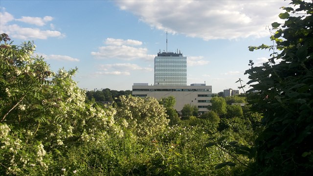
This is a small climbing cache where no equipment is needed. He climbs up on a slope and then ends on a sort of natural "viewing platform".On the way to cache a CITO would be appropriate, but the subsequent view is worth it!
The "mountain" is composed of useless debris. After the air raid almost the entire city was destroyed, they tried to reuse the debris. But not everything could be reused, and this part of the debris was piled up here. You can still see through the vegetation small debris.
When you go to the cache you'll find plenty of parking along the way, because it's a dead end, and thus are usually sufficient roadside free, if not exactly great events take place in the hall next to it. Please do not drive directly to the starting coordinates, it is a way for school children to the sports hall. Arriving at the starting coordinates you see on the side of the little mountain a small dirt track leading into the bushes. At the end of the path since then on her ascent. Whom have you climbed this you are on the "viewing platform". To show the next cachers what they can expect to make her even a picture of the view. In the cache is also space for a GeoKrety.
Peak hours on school days between 9.00 und 13.30 clock clock. There, you will most likely meet school children (on the way to the cache).
It is not recommended in wet weather or frost. Caution falling!
Now, finally, Happy hunting!
By: "born_to_cache"
By: "2Slow4You"
![]() Additional hint
Additional hint
![]() Decrypt
Decrypt
Fgbar
A|B|C|D|E|F|G|H|I|J|K|L|M
N|O|P|Q|R|S|T|U|V|W|X|Y|Z
![]() Pictures
Pictures
![]() Utilities
Utilities
 Search geocaches nearby:
all -
searchable -
same type
Search geocaches nearby:
all -
searchable -
same type
 Download as file:
GPX -
LOC -
KML -
OV2 -
OVL -
TXT -
QR-Code
Download as file:
GPX -
LOC -
KML -
OV2 -
OVL -
TXT -
QR-Code
 When downloading this file, you accept our terms of use and Data license.
![]() Log entries for Hanauer Bersch
Log entries for Hanauer Bersch
![]() 4x
4x
![]() 0x
0x
![]() 1x
1x
![]() 1x
1x

![]() New coordinates:
N 50° 09.***' E 008° 55.***'
New coordinates:
N 50° 09.***' E 008° 55.***'

 15 February 2015
pirate77
has locked the cache
15 February 2015
pirate77
has locked the cache
The user account has been disabled.
![]() New coordinates:
N 00° 00.***' E 000° 00.***'
New coordinates:
N 00° 00.***' E 000° 00.***'
 16 March 2014, 09:00
icaros
found the geocache
16 March 2014, 09:00
icaros
found the geocache
Heute morgen (mit p  ) den Bersch erklettert,der Aufstieg war OK,
auf der Plattform schnell gefunden,Danke,
das Runterkommen gestaltete sich etwas schwieriger.(Handschuhe gegen Dornenstiche)
schöne Aussicht 
Blick durch die Vegetation

08 March 2014
meteofrog
found the geocache
Diese Kletterpartie war mal eine willkommene Abwechslung zu anderen T4 Caches. Da es heute trocken war, war der Auf- und Abstieg kein Problem. Vom Monte Scherbelino hatte Ich bereits gehört, wusste aber nie wo er ist. Das finden eines Parkplatzes war bei der Sportveranstaltung allerdings mindestens ein D4.
TFTC
meteofrog
06 January 2014
horizontx
found the geocache
Heute habe ich mich ins Gipfelbuch eingetragen!
Zuerst wollte ich
einen eigenen Pfad erkunden, aber dort wäre ich bald in den Dornen
hängen geblieben. Wenn ich da eingeschlafen wäre, hätte mich vielleicht
nach 100 Jahren ein schwuler Prinz wach geküsst. Brrr, schlimmer
Gedanke!
Also habe ich dort abgebrochen und den offenbar bewährten
Pfad genommen. Nach dem Finden des Schatzes war das gelungene Hinauf-
und Hinunterkommen ein weiteres positives Erlebnis.
TFTC horizontx