| Language: |


|
Country: |


![]()
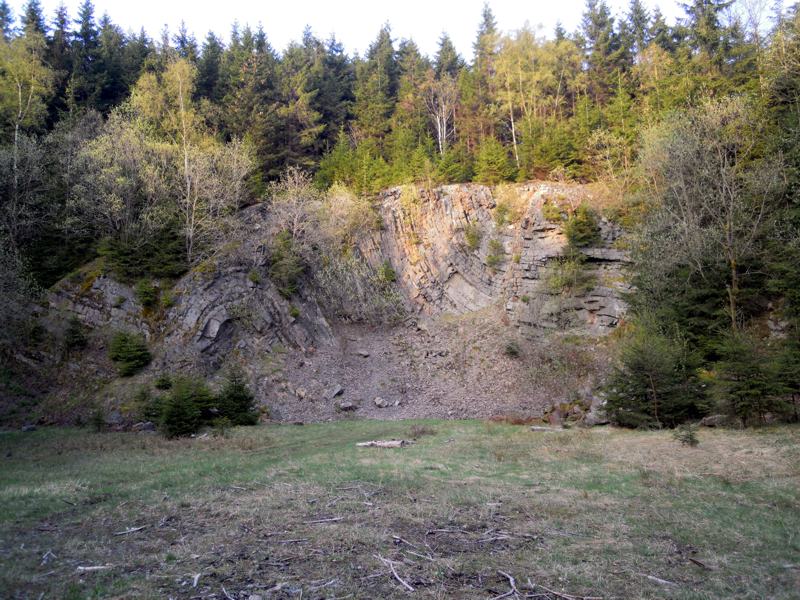
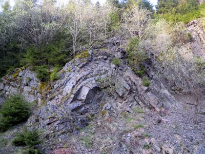
Faltensattel am Wetzstein
Earthcache, Parkplatz siehe Waypoint, < 15min
by wittijack-archiv
 Germany > Nordrhein-Westfalen > Hochsauerlandkreis
Attention! This Geocache is "Archived"! There is no physical container at the specified (or to be determined) coordinates. In the interest of the place it should not be necessarily to search!
|
|
||||
|
|||||


 Size: no container
 Status:
  Hidden on: 11 June 2010
 Also listed at:
  1 Found
 0 Not found
 0 Notes
 0 Watchers
 0 Ignorers
 14 Page visits
 0 Log pictures

![]() Description
Deutsch
(German)
Description
Deutsch
(German)
|
(Foulded Mountain at Wetzstein) |
||
 |
||
|
|
||
|
Die Gestaltung der Erdoberfläche erfolgt in der geologischen Gegenwart vor allem durch das Wasser in Kombination mit Geröll und Sand. Durch die Erosion schafft hartes Gestein steile und tiefe Täler, wie das Helle-, Orke- und Nuhnetal, weniger hartes dagegen sanfter abfallende und breite Täler, wie das Ruhr-, Namenlose- und Helletal.
ACHTUNG: Leider ist das Schild nicht mehr vor Ort. Bis auf weiteres gebe ich das gesuchte Wort vor: steinbruch Beispiel: |
||
|
|
||
|
A picture of yourself and / or the GPS in front of the quarry with the visible folded mountain would be nice. Please answer the following questions:
|
||
|
Quelle: Wikipedia |
||

|
In unmittelbarer Nähe zu diesem Cache findet Ihr auch die beiden schönen Caches: Wetzstein-Cache (GCK88N) von Kampfgurke An der Odeborn 1/9 (GCRCY3) von Die Odeborncacher |
PrefixLookupNameCoordinate PW PW Parken "Faltensattel am Wetzstein" (Parking Area) N 51° 10.523 E 008° 29.831 Note:
![]() Pictures
Pictures
![]() Utilities
Utilities
This geocache is probably placed within the following protected areas (Info): Landschaftsschutzgebiet LSG-Teilgebiet der Stadt Winterberg (Info), Naturpark Rothaargebirge (Info)
 Search geocaches nearby:
all -
searchable -
same type
Search geocaches nearby:
all -
searchable -
same type
 Download as file:
GPX -
LOC -
KML -
OV2 -
OVL -
TXT -
QR-Code
Download as file:
GPX -
LOC -
KML -
OV2 -
OVL -
TXT -
QR-Code
 When downloading this file, you accept our terms of use and Data license.
![]() Log entries for Faltensattel am Wetzstein
Log entries for Faltensattel am Wetzstein
![]() 1x
1x
![]() 0x
0x
![]() 0x
0x
 01 October 2010
crisb
found the geocache
01 October 2010
crisb
found the geocache
Wow, wirklich beeindruckend, was die Natur hier geschaffen hat.
Toller Ort für einen Earthcache.
Gruß crisb