| Langue : |


|
Pays : |


| Suivez-nous : | |||
| Contact us: | |
| Rejoignez les discussions : | ||||
|
|
Forum d'Opencaching | |||

|
Groupe Facebook | |||

|
GitHub | |||

|
Mattermost | |||

 Allemagne > Bayern > Schweinfurt, Landkreis
|
|
||||
|
|||||

 Taille : normal
 Statut : disponible
 Temps nécessaire : 1:00 h
 Caché en : 14.10.2025
 Aussi listé au :
  0 trouvé
 0 pas trouvé
 0 Remarques
 0 Observateurs
 0 Ignoré
 86 Visites de la page
 0 Images de log

| Dangers |

|
| Infrastructure |

|
| Temps |

|
| Saisonnier |

|
| Personnes |

|
![]() Description
Deutsch
· English
(Anglais)
Description
Deutsch
· English
(Anglais)
A small biotope between Hausen and Üchtelhausen…
According to oral tradition, there was a settlement here in the Middle Ages called Weipoltsdorf with about six to eight houses. However, these did not survive the Thirty Years' War, so that no traces of them can be seen today. After the war, there were countless wet meadows here, but these fell victim to land consolidation in the 1960s.
In 1993, the Erhard family from Üchtelhausen acquired a piece of land that had previously been used for agriculture. After extensive landscaping measures in cooperation with the nature conservation authority, a wetland biotope with a pond area was created. Today, it is a habitat for a variety of protected animals and plants, including numerous species of dragonflies.
 Des waypoints supplémentaires
  Autres systèmes de coordonnées
|
N 50° 05.401' E 010° 16.291' |

 Les autres points de passage sont affichés sur la carte lorsque le cache est sélectionné, sont inclus dans le téléchargement de fichiers GPX et seront envoyés à l'appareil GPS.
![]() Indice additionnels
Indice additionnels
![]() Déchiffrer
Déchiffrer
Fbzrguvat vf uvqvat va n ynetr, ebhaq guvat...
A|B|C|D|E|F|G|H|I|J|K|L|M
N|O|P|Q|R|S|T|U|V|W|X|Y|Z
![]() Utilités
Utilités
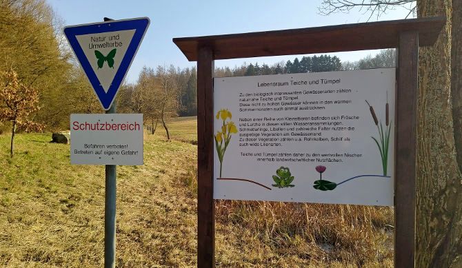
Cette géocache est probablement placé dans les zones de protection suivantes (Info) : Landschaftsschutzgebiet LSG "Hausener Tal" (Infos)
 Chercher des géocaches prés:
tous -
trouvable -
même type
Chercher des géocaches prés:
tous -
trouvable -
même type
 Télécharger en fichier :
GPX -
LOC -
KML -
OV2 -
OVL -
TXT -
QR-Code
Lors du téléchargement de ce fichier, vous acceptez nos conditions d'utilisation et la licence de données.
Télécharger en fichier :
GPX -
LOC -
KML -
OV2 -
OVL -
TXT -
QR-Code
Lors du téléchargement de ce fichier, vous acceptez nos conditions d'utilisation et la licence de données.
![]() Logs pour Kleines Biotop
Logs pour Kleines Biotop
![]() 0x
0x
![]() 0x
0x
![]() 0x
0x