| Langue : |


|
Pays : |


| Suivez-nous : | |||
| Contact us: | |
| Rejoignez les discussions : | ||||
|
|
Forum d'Opencaching | |||

|
Groupe Facebook | |||

|
GitHub | |||

|
Mattermost | |||

![]()
 Allemagne > Hessen > Rheingau-Taunus-Kreis
Attention ! Cette géocache est "verrouillé, visible"! Il n'y a pas une conteneur physique aux coordonnées spécifiées (ou déterminées). Dans l'intérêt de l'endroit il ne devrait pas être nécessairement à la recherche !
|
|
||||
|
|||||


 Taille : aucune boîte
 Statut :
  Temps nécessaire : 1:00 h
 Caché en : 10.01.2013
 3 trouvé
 0 pas trouvé
 0 Remarques
 1 Log maintenance
 0 Observateurs
 0 Ignoré
 190 Visites de la page
 2
2 

| Infrastructure |

|
| Waypoints |

|
| Temps |

|
| Saisonnier |


|
| Inscription |

|
| Personnes |

|
![]() Description
Deutsch
· English
(Anglais)
Description
Deutsch
· English
(Anglais)
Loess at Sonnenberg
The loess in the Eltviller solar mountain is especially worth mentioning there here the biggest layer thickness (thickness) in the region exists.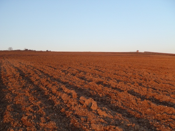
Loess or loess is transported by wind and wind-deposited sediment, consisting of fine material - primarily silt - is. The vast majority of the earth today occurring loess was deposited during the Pleistocene. Here at Eltville Sonnenberg know the loess a considerable thickness (width) of 3 - 8m. The term loess was introduced in 1823 by Karl Caesar von Leonhard in the geological and mineralogical literature. The term is received from a term in many languages.
Features:
Loess consists for the most part made of silt. The clay content is fresh loess in highly variable, from 5 to about 20%, and by weathering may increase. Loess is mixed with highly variable amounts of fine sand, its share of the mixture is on average 20%, but may also be higher. When sand contents above 50% but still abundant silt is referred to as Sandlöss, known regionally as Flott sand. Nevertheless, loess is regarded as well-sorted sediment. Mineralogical Loess consists largely (50% - 80%) of quartz grains with 8% - 20% limestone fragments. Admixtures of iron hydroxides loess color yellow to yellowish-red. Other minerals such as feldspars, volcanic glass or mafic minerals, come i.d.R. present in small amounts, but can be regionally dominant also, as in Argentina or in the North Island of New Zealand. Loess is usually unstratified, unconsolidated and very porous, but can be obtained from subsequent rearrangement of water stratification and then called alluvial loess. General sediments caused by rearrangement of loess are called Lössderivate. The porous structure is explained probably by the grass stems, between which the loess was deposited during sedimentation. Concretions of calcium in the loess caused by solution and reprecipitation of the finely divided calcareous fragments and are called Lösskindl or Lössmännchen. The individual particles in the loess have a predominantly square shape. This explains its high stability, the formation of loess hills along river banks, in ravines, and encouraged the development of agricultural terraces.
Created:
Loess is formed when silt and fine sand is blown in the absence of vegetation cover and after a long transport (several tens to several hundreds of kilometers) in areas with denser vegetation deposited. In Central Europe, loess is produced mainly in the ice ages, as a result of low temperatures throughout the year there was no vegetation; the foreshore areas of the glacier and the floodplains were even largely free of vegetation. Responsible for the loess formation were both the prevailing westerly winds and the frequent periods in the cold, dry and cold fall winds. The latter fell from the almost entirely glaciated Alps and the Scandinavian ice sheet down and took in the foothills of fine grained material. While the sand covers only a relatively short transport distances and was deposited in the form of inland dunes, was much finer material such as silt blown further and deposited as loess cover more extensively. Especially along the river areas - such as the Upper Rhine and the Danube - the loess was blown by the westerly winds and deposited far beyond the river again: e.g. Kraichgau east, in the Danube valley in the north-east of the river Wagram. In the Rhine-Meuse Delta, the Lössareas are on the left bank of the river, far away from the river west neighbor, while the east bank covered terrace of a pagan little far-drifted sand. The formation of loess is taking place but also warm and dry climate, when blown dust from deserts and in the peripheral areas, which can again flourish vegetation, deposited.
Loess sediments and Lössderivate:
Already a while, but after the loess deposit can be moved by other processes as wind. Depending on the process, a distinction is Kriechlöss (slightly rearranged on a slope), Fließlöss (rearranged by solifluction, usually contains a rough skeleton of the loess in the upcoming material), alluvial loess (rearranged by rinsing), Hangrutschungslöss, Infusionslöss (rearrangement in a lake), Kryoturbationslöss (mixed by freeze-thaw cycles). Furthermore, the weathering attacks mainly the upper areas of the loess. This will solve the lime and clay minerals formed. The result is loam. All named varieties of the loess is called Lössderivate.
![]() Utilités
Utilités
Cette géocache est probablement placé dans les zones de protection suivantes (Info) : Landschaftsschutzgebiet Rhein-Taunus (Infos)
 Chercher des géocaches prés:
tous -
trouvable -
même type
Chercher des géocaches prés:
tous -
trouvable -
même type
 Télécharger en fichier :
GPX -
LOC -
KML -
OV2 -
OVL -
TXT -
QR-Code
Télécharger en fichier :
GPX -
LOC -
KML -
OV2 -
OVL -
TXT -
QR-Code
 Lors du téléchargement de ce fichier, vous acceptez nos conditions d'utilisation et la licence de données.
![]() Logs pour Löss am Eltviller Sonnenberg
Logs pour Löss am Eltviller Sonnenberg
![]() 3x
3x
![]() 0x
0x
![]() 0x
0x
![]() 1x
1x

 15.11.2013
pirate77
a verrouillé la géocache
15.11.2013
pirate77
a verrouillé la géocache
Der Benutzeraccount wurde deaktiviert.
 11.06.2011
Määnzer
trouvé la géocache
11.06.2011
Määnzer
trouvé la géocache
Zusammen mit "A-und-A" auf unseren heutigen "Feierabend-Tour" mal kurz die Stelle fürs Foto besucht.
Eine Horde Jugendlicher haben hier ihr all abendliches Pfeichen geraucht ...
TFTC
MÄÄNZER
HB
This entry was edited by Määnzer on Sunday, 20 May 2012 at 19:52:36 UTC.
Löss am Eltviller Sonnenberg

Löss am Eltviller Sonnenberg

10.05.2011
Eichelhäher
trouvé la géocache
Bei einbrechender Dunkelheit hat dieser Ort schon was Schönes. Und erst der tolle Blick auf die andere Rheinseite. Ein sehr schönes Fleckchen Erde dort drüben.:grin:
Vielen Dank fürs Zeigen dieses EC.
Viele Grüße, [green][b]Eichelhäher[/green][/b].
10.05.2011
Sturnus Canus
trouvé la géocache
Schönes Plätzchen und ein netter Earthcache . Da war es dann auch wieder mal Zeit für Kodak Moments.
Vielen Dank für den Cache,
Mahatma Sturnus Canus der Graue Star bekannt aus Funk & Fernsehen
Finder des hl. Grals - Fanal am Horizont