| Taal: |


|
Land: |


- Hoofdmenu
- Zoeken
- Maak een cache
- Beschrijving
- Toegestane HTML Tags
- My caches
- Bijzondere Caches
- Cache lists
- OConly-81


 Duitsland > Bayern > Schweinfurt, Landkreis
|
|
||||
|
|||||

 Grootte: normaal
 Status: Beschikbaar
 Benodigde tijd: 1:00 h
 Verborgen op: 14.10.2025
 Ook gepubliceerd op:
  0 Gevonden
 0 Niet gevonden
 0 Opmerkingen
 0 Volgers
 0 Negeerders
 86 Bekeken
 0 Log pictures

| Gevaren |

|
| Infrastructuur |

|
| Time |

|
| Seasonal |

|
| Personen |

|
![]() Beschrijving
Deutsch
· English
(Engels)
Beschrijving
Deutsch
· English
(Engels)
A small biotope between Hausen and Üchtelhausen…
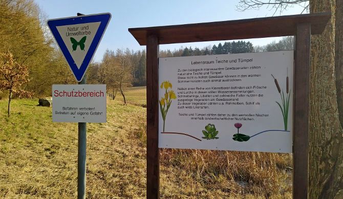
According to oral tradition, there was a settlement here in the Middle Ages called Weipoltsdorf with about six to eight houses. However, these did not survive the Thirty Years' War, so that no traces of them can be seen today. After the war, there were countless wet meadows here, but these fell victim to land consolidation in the 1960s.
In 1993, the Erhard family from Üchtelhausen acquired a piece of land that had previously been used for agriculture. After extensive landscaping measures in cooperation with the nature conservation authority, a wetland biotope with a pond area was created. Today, it is a habitat for a variety of protected animals and plants, including numerous species of dragonflies.
 Additional waypoints
  andere coördinaatstelsel
|
N 50° 05.401' E 010° 16.291' |

 The additional waypoints are shown on the map when the cache is selected, are included in GPX file downloads and will be sent to the GPS device.
![]() Gecodeerde hint
Gecodeerde hint
![]() Decoderen
Decoderen
Fbzrguvat vf uvqvat va n ynetr, ebhaq guvat...
A|B|C|D|E|F|G|H|I|J|K|L|M
N|O|P|Q|R|S|T|U|V|W|X|Y|Z
![]() Hulpmiddelen
Hulpmiddelen
This geocache is probably placed within the following protected areas (Info): Landschaftsschutzgebiet LSG "Hausener Tal" (Info)
 Zoek caches in de omgeving:
alle -
zoekbaar -
zelfde cache soort
Zoek caches in de omgeving:
alle -
zoekbaar -
zelfde cache soort
 Download als bestand:
GPX -
LOC -
KML -
OV2 -
OVL -
TXT -
QR-Code
When downloading this file, you accept our terms of use and Data license.
Download als bestand:
GPX -
LOC -
KML -
OV2 -
OVL -
TXT -
QR-Code
When downloading this file, you accept our terms of use and Data license.
![]() Logs van Kleines Biotop
Logs van Kleines Biotop
![]() 0x
0x
![]() 0x
0x
![]() 0x
0x