| Sprache: |


|
Land: |


- Auswahl
- Suchen
- Verstecken
- Beschreibung
- Erlaubte HTML-Tags
- Meine Caches
- Empfohlene Caches
- Cachelisten
- OConly-81


A glimpse of history: Border walk in Schlossberg
von cezanne
 Österreich > Steiermark > West- und Südsteiermark
|
|
||||
|
|||||

 Größe: kein Behälter
 Status: kann gesucht werden
 Zeitaufwand: 3:45 h
 Versteckt am: 19. August 2018
 Auch gelistet auf:
  0 gefunden
 0 nicht gefunden
 0 Bemerkungen
 1 Beobachter
 0 Ignorierer
 182 Aufrufe
 0 Logbilder

| Gefahren |


|
| Infrastruktur |

|
| Der Weg |


|
| Zeitlich |

|
![]() Beschreibung
Deutsch
· English
Beschreibung
Deutsch
· English
Part 1: General information
Preparation:- Please study the logging requirements of this virtual detailed in Part 2 carefully before you start off.
- Do not forget to take a travel document with you (even if you do not intend to visit Sveti Duh.).
- Please take into account that you might not have cell phone reception in some sections. I strongly recommend you to not rely exclusively on your smartphone. If you absolutely want to go paperless, I suggest that you prepare yourself and download in advance whatever you might need (maps, waypoints, pdf documents etc).
As a special service for those who are scared by long cache descriptions, I created a pdf file that contains the logging requirements as well as two pdf files which only contain the field work part, one with background information and one without.
Target audience/What to expect: This virtual targets at cachers with an interest into (contemporary) history who do not mind (or even enjoy) to go for a walk beyond the 5km barrier and who are willing to invest at least two hours. To accomodate for a larger audience, the cache is offered in two versions, LW (longer walk) and SW (shorter walk), for details see Part 2.
Warnings/What not to expect: To avoid foreseeable disappointments please note the following
- If you seek out for a quick virtual on a day packed with many other activities, this cache is definitely not a good fit for you.
- Keep in mind that the virtual touches upon some dark chapters of history. If you search for a cache which provides light entertainment, this might not be the right cache for you.
- If you just want to go for a nice walk and have no interest into the history of the area, then this cache will not be a perfect fit for you. You might easily feel that reading the description and following the logging tasks distracts you from the walk.
Route information: The round trip walks for both versions start and end at the Moserhof inn in Grosswalz. The route involves a mixture of small forest trails, logging roads, meadow paths, field tracks as well as a section along a paved road. In a significant part of the walk you follow the borderline or are very close to it. To get an impression of what to expect have a look at my photo collection (taken on two different days).
In the first section and the last section the trails are well maintained and most of them are marked or otherwise easy to follow. In the middle section (between Stages 4 and
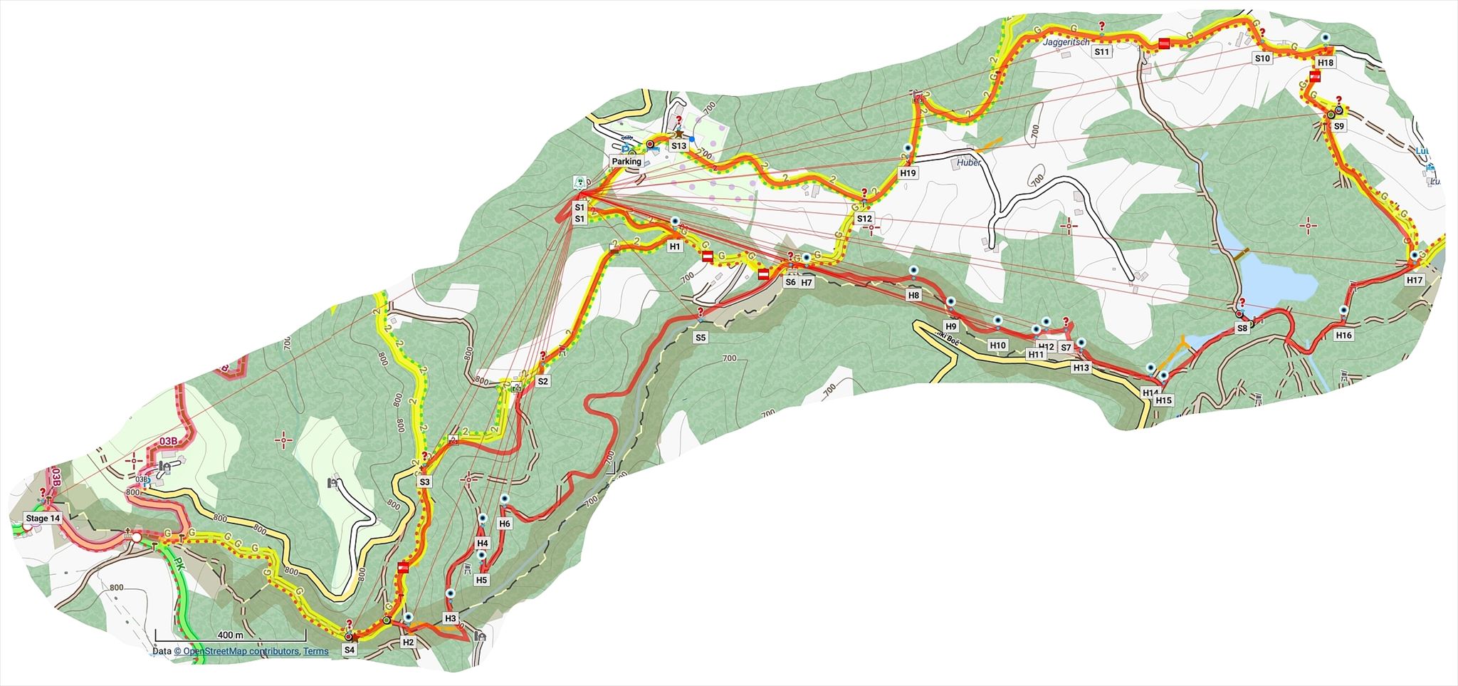
 you follow a route along non marked trails. I have added a number of auxiliary waypoints for this section. You might however still want to bring along a map. AnnaMoritz has been so kind to create a very nice overview map of the cache route (including all waypoints) based on openstreet map. This sketch by Günter Auferbauer might be helpful too, but parts of it are outdated and not all shown trails still exist. .
Terrain: For the long version LW expect a walk of approximately 11 km and 300 height meters elevation change (including ups and downs along the way. The terrain rating of 2.5* has been chosen due to the length of the tour and the overgrown sections along unmarked paths.
Time requirements: For the LW version (recommended), plan for 3-4.5 hours (including the time to accomplish the logging tasks and short breaks). Very fit cachers who do not take breaks will be able to finish faster. Please do not go for the walk when it is dark.
Public transportation: The start is not reachable by public transportation. However, Leutschach is reachable by bus from Leibnitz where you can easily get by train. To get to the Moserhof inn you can make use of the recently introduced IST Mobil service (Region Südwest). The prices are reasonable, but prior booking is required.
Parking: Those who come by car can park at one of the parking areas around the Moserhof inn or the winery Moser.
Food and beverages: Except for the Moserhof inn at the start (for the opening times which vary with the season, please consult this webpage) there are no locations to buy food or beverages directly along the cache route.
Part 2: Logging Requirements
As a 10+km walk (partially along unmarked, not well maintained paths) is not for everyone, I decided to offer two versions of this virtual, the LW version, which involves a longer walk, and the SW version which involves a shorter walk, but requires the usage of a vehicle. Both versions include the key locations of this cache. For the full experience I recommend to go for the LW version.
Depending on the chosen version the logging requirements differ. Please study them in detail. Found it logs that do not comply will not be accepted!
- Long version (LW): All stages required for this version are located along a round trip walk. Interim usage of a vehicle is neither required nor desired.
Your agenda for LW: Visit Stages 1-13 and fulfill Photo Tasks 1-5 and Question Tasks 1-9. Stage 14 (Sveti Duh) and hence Question Task 10 and Photo Task 6 are not part of this version and can be skipped. - Short version (SW): This version involves a shorter round trip walk to visit Stages 1-6 followed by Stages 12 and 13. Stages 11 and 14 can be visited by a vehicle (after or before your round trip SW walk). Please walk over to Stage 10 from Stage 11 and do not drive up to Stage 10 (to avoid to arise attraction which would endanger the existence of this cache).
Your agenda for SW: Visit Stages 1-6 and 10-14 and fulfill Photo Tasks 1,2, 3, 5 and 6 and Question Tasks 1-3 and 6-10. Stages 7 (Bench) , 8 (Schmirnberg ponds) and 9 (Lube) and thus Photo Task 4 and Question Tasks 4 and 5 are not part of this version and can be skipped. - Combined LW+SW: If you are ambitious, do not mind long walks and want to visit Sveti Duh on foot anyway, there exists the further option to fulfill the logging requirements of both LW and SW within a single walk. To that end, make a detour to Stage 14 (Sveti Duh) by interrupting the suggested round trip walk at Stage 4 (southernmost point) and then return to Stage 4 via the same way and continue to Stage 5.
Logging and photo requirements
In order to be eligible for a legitimate found it log you need to fulfill the following requirements.
- Question Tasks: Send me the answers for all question tasks associated with your chosen version (LW or SW).
If it inconveniences you, you do not need to wait for my reply, but you need to send your answers before submitting your log. I'd appreciate if you contact me via e-mail. (Comment: I intentionally decided against using an auto-responder.) - Photo Tasks: Upload the photos required for your chosen version to your log (within 2 days, i.e., 48 hours of posting your log). Make sure that the photos meet the photo requirements explained below (example of eligible photo for Photo Task 1).
- Each photo associated with a photo task must show the required object.
- Each such photo must include either yourself or your GPS or your signature item.
- Each such photo must include a sheet of paper (or something comparable) with your geocaching alias and the date of your visit. It is not acceptable to include this information by some photo manipulation software.
Further photos are welcome as long as they do not contain spoiler information for any of the question tasks.Part 3: Field Work
Start (Moserhof) N 46° 37.404' E 15° 28.952'
Parking is available at the parking lot of the Moserhof restaurant or the winery Moser.
Route information: Start your walk at the trailhead and head for Stage 1 at the header coordinates. To some it might be tempting to start with the closer Stage 13, but I recommend to leave that stage for the end for dramaturgical reasons.Stage 1 (Former millstone quarry) N 46° 37.357' E 15° 28.852'
You now have arrived at the former Moser quarry where until to the thirties of the last century millstones got mined.
Photo Task 1: Take a photo of the quarry which meets the photo requirements for this virtual explained above (my example photo).
Background information: In the 19-th century several millstone quarries and one for ironstones existed in the area of Schloßberg (larger back then). The millstones where used in grain and fruit mills and were not only used in the many local mills, but also got transported to other locations in Styria. The grandfather of the senior boss of the Moser winery, Hugo Kapun, had been working in this quarry. Some historical photographs are exhibited in the farm store of the winery.
Route information: From the quarry follow the trail downwards along the creek. Head for waypoint HELP 1. There you will meet the border panorama trail (Grenzlandpanoramaweg, GPW for short) which will stay your companion until Stage 4.Stage 2 (GPW sign post) N 46° 37.108' E 15° 28.776'
You have arrived at a signpost which shows you your further way. If the weather permits, do not forget to enjoy the nice view nearby.
Question Task 1: Two signs inform you about the expected walking times along the Grenzlandpanoramaweg trail.- A(1): The sum of the two walking times (in minutes).
Background information: The Grenzlandpanoramaweg (border panorama walk, GPW for short) leads from Soboth to Bad Radkersburg and mainly follows the route of the 03 long distance hiking route.
The nearby homestead has the vulgo name Krabat. The homesteads in this area are often at quite a distance from each other (one of the main reasons being that a lot of the area is covered by wood which means that larger properties were required to allow for a living). In this setting the term neighbour gets a different meaning than in an urban or semiurban setting - it's not as easy just to jump over to your neighbour to get help if needed.Stage 3 (Gradischnigg cross) N 46° 36.964' E 015° 28.529'
The Gradischnigg cross should now be in your view.
Question Task 2: Have a look at the lower part of the vertical bar of the cross. Watch out for 8 encarved digits.- A(2): The sum of the eight digits.
Route information: Continue to follow the marked GPW trail which leads you to Stage 4, the real southernmost point of Styria. On your way you can visit the Südlichster Punkt der Steiermark traditional.Stage 4 (Southernmost point) N 46° 36.723' E 15° 28.372'
You have arrived at the southernmost point of today's Styria. Border stone 314 marks this point.
Photo Task 2: Take a photo of the border stone and the sign which meets the photo requirements for this virtual.
Background information: As a result of Word War I and the Treaty of Saint-Germain-en-Laye from 1919, the region of Lower Styria (Untersteiermark), which for many centuries belonged to Austria, became part of the SHS state respectively the Kingdom of Slovenes, Croats and Serbs .
In this some sections of this newly created border the St Germain treaty did not define the exact borderline. It was neither possible to define the border based on the spoken language nor was everywhere a natural object like the river Mur available. As a result, in many cases the new borderline was determined by tiresome negotiations on a case by case basis. In some areas the affected people could decide to which side they wanted to get assigned or managed to get the border shifted by a few m (like for example in the case of Franz Tertinjek at the Remschnigg, but many times the property of people got divided up into parts lying in different countries. Some of wounds that have been created back at the time when Styria got separated (and even before due to the uprise of nationalism) have never been fully healed until these days.
Route information: For reaching the next stage, make a U-turn and head for the rest area which is sold touristically as the southernmost point (waypoint HELP 2). For those who want to walk to Sveti Duh, that's the point to temporarily interrupt the described round trip walk. In case you want to claim a find for the SW version, do not forget to fulfill the tasks at Sveti Duh (cf Stage 14). After your return from Sveti Duh, then continue with the rest of the tour.The false southernmost point N 46° 36.734' E 015° 28.495'
After approximately 2.5km and 150 height meters you might want take the chance for a little rest. The location which is marketed as southernmost point of Styria does not provide the promised, but offers a small rest area. The border stones 304 and 305 are nearby.
Background information: The little gorge which you will soon get to see is formed by the border creek (Großwalzer Bach) and is known as Huberklamm. I has its name due to the vulgo name of the property's owner homestead. The name Huberklammweg can be found on some maps and it appears that in former times there existed a small adventurous (probably gebu-like) trail down in the gorge, see also the description of Tour 51 in the book Günter und Luise Auferbauer, 100 Ausflüge um Graz, Touren 51–100, 2009, Styriabooks, Graz, ISBN 3-222-13241-4. However, according to the experience of Gert and his company and my own experience at the occasion of two exploration trips in 2018 I decided that it might not be a good idea to make you walk directly at creek level and so I decided to guide you along logging roads, see the description below.
Route information: In the next section navigation will be a bit harder as you are not following any longer a marked route. For this reason, I have added several auxiliary waypoints. Right at the rest area a small trail starts that essentially follows the borderline and leads down to border stone 299 and the Knapp source (waypoint HELP 3). Nearby you can see the remainings of a lime kiln. At the source follow the overgrown logging road to the left (and not the trail going down from the source to a house). At the next possibility (waypoint HELP 4) take a sharp turn to the right. When having reached HELP 5 the trickier part is behind you - now a comfortable walk along a logging road is ahead of you. Waypoint HELP 6 is the last auxiliary waypoint on your way to Stage 5.Stage 5 (Border creek) N 46° 37.170' E 015° 29.104'
You have now walked close to the border for quite a while. Most of the time the logging road was well above the creek level but now you arrived close to the creek (Großwalzer Bach) which forms the border here.
Photo Task 3: Take a photo of the border stone 278 which meets the photo requirements for this virtual.Stage 6 (Wresnik cross) N 46° 37.250' E 15° 29.292'
You have arrived at the Wresnik cross named after the nearby homestead.
Question Task 3: Have a look at the back side of the cross. Focus on the little square-like area where the horizontal bar and the vertical bars that form the cross shape meet.- A(3): The number of screw heads within the little square.
Route information: Your further routes depends on whether you have decided for the LW (longer, my recommendation) or the SW (shorter) version.- Option LW: Proceed next to Stage 7 (route not marked, see description below) and continue to visit the stages in chronological order.
- Option SW: Proceed to Stage 12 (the route should be obvious) from here and then further on to Stage 13 (close to the start point). The remaining stages 11, 10 and 14 can be visited independently.
Stage 7 (Bench) N 46° 37.155' E 015° 29.866'
A bench with an attached table should be in your view. Take a seat and have a look at the object to the left of the bench. Watch out for a metal plate.
Question Task 4:- A(4): Which text is written on the plate?
If you fail to find the plate, proceed with the backup question: Continue along your way. Soon you will reach a gate. At the right side a golden object is attached.
Backup question- A'(4): Which word is written in capitals on that object?
Background information: There is not much to say about this stage. Note that the road you can see is already in Slovenia and it is easy to get there and legal and safe these days. During my break I reflected about how glad I'm that I'm having a good and safe life and how difficult the life of people must have been in this area in the first half of the last century.
Route information: At HELP 13 you pass a gate. The waypoints HELP 14 and HELP 15 guide you over the creek and to a logging road which you then just need to follow to the ponds and to Stage 8. Navigation has become easy again.Stage 8 (Schmirnberg ponds) N 46° 37.183' E 015° 30.234'
You have arrived at the shore of one of the Schmirnberg ponds. A little plank should be in your view. If you have not been at the ponds before, you might want to search for the nearby Die drei Teicht traditional (which however is in miserable condition).
Photo Task 4: Take a photo of the pond's shore at the plank which meets the photo requirements for this virtual.
Background information: The Schmirnberg ponds once belonged to the owners of the Schmirnberg castle which in former times has been a very prominent castle of which now only a fragmentary ruin in bad condition is left over. The Schmirnberg manor comprised of the Schmirnberg castle, a feudal estate that later developed in Trautenburg castle, the Amtmann estate, the regional court and the toll stage in Leutschach, extended hunting grounds and fishing waters. The Schmirnberg castle (ruin) as well as the Schmirnberg ponds have experienced many different owners over the centuries. They are now privately owned and fishing and swimming is prohibited for non authorized people. If you have never been at the Schmirnberg ruin and have some spare time, I'd strongly recommend a visit which even can be combined with a cache.
Route information: Follow the logging road further towards waypoint HELP 16 and further on to HELP 17 where you turn left into the border panorama trail (GPW) which will lead you to Stage 9.Stage 9 (Lube wayside shrine) N 46° 37.473' E 15° 30.436'
You now have arrived at the Lube wayside shrine which has its name due to the nearby homestead Lube. Each of the four sides is decorated with paintings. At the front side there is a cross; the three other sides each contain a large painting of a saint. Let's have a closer look at these paintings.
Question Task 5: On the back side (opposite the bench side) a painting depicts a female saint.- A(5): What objects does the female saint have in her hands? In case you have problems identifying the objects in her right hand, you can alternatively name the object above her right shoulder.
- Optional bonus questions: What is the name of the female saint? What are the names of the two male saints depicted on the left and the right side (seen from the direction of the bench)?
Route information: Follow the GPW trail up to the paved road which you meet near waypoint HELP 18. Turn left there and follow the road to Stage 10.Stage 10 (Hammerkautz memorial) N 46° 37.570' E 15° 30.276'
You are now in view of a cross and a memorial stone which commemorates the tragic death of three policemen in 1947. The nearby homestead has the vulgo name Hammerkautz.
Question Task 6:- A(6): Which name and year date which are not connected to the 1947 incident are mentioned on the stone?
- Optional bonus question: Why is this additional person mentioned on the stone?
Background information: The Hammerkautz stage is the one around which my idea for this virtual evolved. For that reason, I will provide more detailed background information than for most other stages.
The Hammerkautz homestead, which has been the home of the Körbler (Kerbler in Slovenian) family, played an important role in the history of the area in the 1930s and 1940s. The farm has also been the interim home for the school before the new school building (see Stage 11) got built.
Difficult after war period
With the end of WW II, the turbulent times for the border region had not come to an end. In the area around Leutschach many violent incidents happened.The year 1947 formed a climax of the highly insecure situation.
While the people had hoped for peace, rather the situation became more difficult, aggravated by Yugoslawian claims for Austrian territory and the fact that inner Yugoslawian fights between the Communist side (partisans, Yugoslawian state) and opponents (anti-communist groups and diverse gangs) were extended over to Austria (and partly organized from refugee camps in Austria like the one in Leibnitz). The hilly and not easily accessible terrain of the border region provided many options to hide and to operate in secret which was of particular importance to the illegal groups fighting against the Yugoslawian state as they were hunted by the Yugoslawian State Security Administration (UDBA).
The motivation to join anti communist groups were diverse: some members had a religious background, some a German nationalist one and others a royal one (aiming at the return of the Kingdom of Yugoslawia and the exiled king). For that reasons, these groups are sometimes associated in the literature with terms like Crusaders (Križari), Matjaž movement (after King Matjaž) , White Guards and others. It would go far beyond the scope of this cache description to provide more details about the different groups that played a role in this conflict and till today the topic is not fully researched. For the context of the Hammerkautz incident in 1947 the so-called Sernec gang, a group of anti-communist royalists around the Sernec brothers plays a special role. Several of the gang members had family relations to people from the Leutschach area and were supported by them while other locals had family relations with partisans.
About the incident in June 1947
Josef Kerbler, the head of the Kerbler family, had asked for support from the British troops due to a threat he had received. The Kerbler family had family relations with members of the Sernec gang and was known for their anti-partisan stance. The Sernec gang partially operated from the Hammerkautz homestead and other nearby homesteads to which they also had family connections. When 50 British soldiers arrived on June 26 everything was quiet and so they left again and only several local policemen stayed as a guards. One day later when only the 3 policemen were present and no members of the Sernec gang, the Hammerkautz homestead got attacked by a group of men. Two policemen got shot and one was kidnapped and later killed. Moreover, two children of the Kerbler family got shot and two others and their father and their mother got seriously wounded, but survived.
Despite of detailed investigations over several years the criminal case could never be fully resolved. Some blamed the partisans for the attack while others blamed enemies of the Sernec gang. For more details, have a look at Promitzer's PhD thesis, Haring's diploma thesis and Engelke's book, see [3], [4] and [15] from this list.
Smuggling activities and Josef Schleich
As many locals back in those times the people from the Hammerkautz homestead have been involved in diverse smuggling activities for decades. Goods like firestones, flints and saccharin were highly demanded on the Yugoslavian side of the border and goods like meat, wheat, coffee and many other food stuffs were much more expensive on the Austrian side and often not affordable for most locals which were very poor. Again for economical reasons cattle and horses got smuggled during the night over the green border. In the years from 1939-1941 the poultry farmer and smuggler Josef Schleich from Graz established a business which involved smuggling Jews illegally to Yugoslavia. Schleich's business relied on the help of many local smugglers which had excellent knowledge of the area but also on bribing many of the involved persons. The Kerbler family and also the residents of most of the homesteads in the area have been involved in smuggling activities and also in Schleich's business (some worked as local guides and were directly involved in bringing the Jews over the border while others were involved by offering food and shelter for the Jews during the waiting time until the right moment for an attempt to cross the border has arrived).
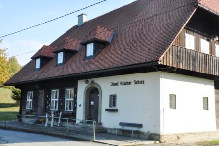
Schleich's (still not very well known) story is interesting in its own right and shows how difficult it can be to decide what is good and what is bad. The Schleich story however definitely goes beyond the scope of this cache. For further details I refer to the list of references . Maybe I will set up a separate cache about Josef Schleich in the future.Stage 11 (Josef Krainer school) N 46° 37.579' E 15° 29.941'
You have arrived at the Josef Krainer school which used to be Styria's southernmost school before it got closed forever in June 2012.
Question Task 7: To the left of the entrance door you will find some signs.- A(7): Which unexpected place name is mentioned on the uppermost sign? (in case of problems consult the hint).
Background information:The school house got built in the years 1948/49 to replace the former German school of Schloßberg which was located in Sveti Duh (Heiligengeist) directly at the border and got destroyed in 1944 by a group of partisans. The still usable bricks of the destroyed school were brought by carriages to the new location and got recycled. The school got named after the long time governor of Styria, Josef Krainer senior, who had been a big supporter of the Styrian border regions.
What should not be withheld however is the inglorious role played by governmental, educational and religious authorities (e.g. Steirische Landesregierung, Landesschulrat, Roman Catholic church) in oppressing the usage of the Slovenian language in church, school and daily life in an area where once Slovenian has been the mother tongue of the majority of the people. The long-standing head teacher Max Weiß-Reinthaler in Großwalz and the nationalist association Alpenländischer Kulturverband Südmark - AKVS, which supported the Josef Krainer school financially, played a prominent role in the process of the German assimilation of the border region.
Even though the Slovenian speaking minority in Styria is mentioned in Article VII of the Austrian State Treaty (Staatsvertrag) from 1955, they never actually got conferred the minority rights that they would have been entitled to get. For a complete picture, it needs to be mentioned however that likewise the German speaking minority in Slovenia also never got acknowledged (in contrast to the situation in Serbia and Croatia). It's tragic to realize how much suffering has been caused and is still caused worldwide by nationalistic attitudes and by valuing nations much higher than human beings.
If you would like to learn more on the shameful treatment of the Slovenian speaking minority in the Styrian border region (which is not as widely known as it would deserve) have a look at Promitzer's PhD thesis, Haring's diploma thesis and the TV documentary on the forgotten minority, see [3], [4] and [1] from this list.Stage 12 (Sign Post) N 46° 37.340' E 15° 29.446'
Now the main part of the walk is behind you.
Question Task 8: Let's have a closer look at the signs at this crossing. Which is the farthest destination mentioned on the signs?- A(8): The expected walking time (in minutes) to reach this destination.
Stage 13 (Moser park) N 46° 37.445' E 15° 29.059'
Now it is time to relax. After having visited a few locations with a sad or at least chequered history, something to cheer you up might be welcome. Let's visit the Moser wellness park.
Photo Task 5: Choose your favourite location within the park and take a photo there that meets the photo requirements for this virtual.
Question Task 9: Search within the park for a small disc which provides information on the distances from the Moserhof to various places around the world.- A(9): The sum of the distance to the city where the Kremlin is located and the distance to the city where the Sagrada familia basilica is located.
Background information: The winery Moser (Weingut Moser) at an altitude of 700 height meters above sea level is Austria's highest winery. Since several generations it is in possession of the Moser Kapun family. If you come during the opening times (from mid March to mid of November, Mo-Sa 9:30-18, Su 9:30-17), you might consider a visit to the farm store (Bauernladen) which also serves as a little museum (no entrance fee) and/or the show distillery.
A special highlight is the Moser wine wellness park to which Stage 13 is dedicated to. The creation works started in 2009. In 2011 the park got officially opened and since then it is open to the public all year round. The large stone hand sculpture at the entrance area has become a kind of signature item of the park. If you come at the right season, you will also be able to admire beautiful roses.Stage 14 (Sveti Duh) N 46° 36.913' E 15° 27.727'
You need this stage only for the SW version . You can go to Sveti Duh by car and park at the stage coordinates. Nearby you will find a sector border stone. Do not forget to enjoy the nice view.
Photo Task 6: Take a photo of the sector border stone which meets the photo requirement of this virtual.
Question Task 10: The cemetery of Sveti Duh is not far from here. Just walk down the road for about 130m and you'll arrive there. Enter the cemetery and watch out for the grave of the Kerbler family and another family (hint: it is located in the front left area).- A(10): What are the first names of the three people with surname Kerbler which are listed on the gravestone?
If you have enough time, you might consider walking up to the church and visiting the Sveti Duh - Heiligengeistkirche traditional.
Background information: Until 1918 Heiligengeist am Osterberg (now Sveti Duh na Ostrem vrhu) belonged to Austria. Josef Körbler (Jozef Kerbler) from the homestead vulgo Kure opted in 1919 for Austria. So his property continued to belong to Austria but he nevertheless regarded himself as Slovenian and not German and continued to speak Slovenian and so did his children. They did not speak any German before they entered school. The two sons of Josef Körbler, Max and Josef, greeted a Nazi neighbour in Slovenian who denunciated then the family with the result that the father of the two boys got deported to Dachau where he died.
There used to be a memorial plate commemorating civilian Nazi victims at the Slovenian school in Sveti Duh below the church. It is shown in the TV documentary Die vergessene Minderheit around 25:00 by Max Körbler, Josef Körbler's son. The school building got renovated in the last years and apparently the plate got removed. It is still visible on this photo from 2010. Well, now the school building looks very nice and clean, but the removal of the plate is yet another step which makes it easier for people to forget what happened.Part 4: Additional study material and suggestions for further border related activities
This cache could only touch the complex history of the Slovenian-Styrian border region on the surface.List of references
There is plethora of books, articles in scientific journals and newspapers and on the internet and TV documentaries that can be used to learn more about the history of the Slovenian-Styrian border region and on related topics. I have a collected a list of references which is far from being complete.
Further border related activities
If you rather prefer hands-on experiences to reading books and articles or viewing TV documentaries, maybe one of the suggestions below appeals to you.- Visit the Pavelhaus (Pavel house, Pavlovi hiša) museum in Laafeld near Radkersburg, N 46° 41.286' E 16° 00.262'.
- Visit the Grenzlandgallerie (border area gallery), project at Langegg, start point N 46° 38.865' E 15° 33.070'.
- Visit the Serschenhof, the home of the Tertinjek family at the Remschnigg, N 46° 38.850' E 15° 25.383'.
- Visit the History Museum in Graz (Museum für Geschichte). From April 19, 2018 until September 2, the special exposition with the title 100 Jahre Grenze I: 1900-1918 Die Zeit vor der Grenzziehung" (100 years of the border I: 1900-1918 - The era before the demarcation)" was on display. The second part which deals with the years 1919-1945 was on display from September 13, 2018 to January 20, 2019.
The
third and last part is on display from February 1, 2019 until May 19, 2019 and deals with the years since 1946.
Part 5: Acknowledgement
I'd like to thank AnnaMoritz for helping me with some aspect of the research on the Hammerkautz memorial and in particular for pushing me towards turning my vague ideas into a virtual cache. Without her encouragement I would have let lapse the chance to submit a second virtual, roughly 15 years after my first one.Virtual Reward - 2017/2018
This Virtual Cache is part of a limited release of Virtuals created between August 24, 2017 and August 24, 2018. Only 4,000 cache owners were given the opportunity to hide a Virtual Cache. Learn more about Virtual Rewards on the Geocaching Blog.
 Zusätzliche Wegpunkte
  andere Koordinatensysteme
|
N 46° 37.357' E 015° 28.852' |
Stage 1 / Station 1 Former Moser quarry/Früherer Mosersteinbruch Photo task 1: Photo of the quarry which fulfills the photo requirements for this virtual (see description) Foto 1: Foto des Steinbruchs, das die Fotobedingungen dieses Virtuals erfüllt (siehe Beschreibung) |
||
|
N 46° 37.108' E 015° 28.776' |
Stage 2 / Station 2 Sign post/Wegweiser Question task 1: Sum of the two walking times in minutes Frage 1: Summe der beiden Wegzeiten in Minuten |
||
|
N 46° 36.964' E 015° 28.529' |
Stage 3 / Station 3 Gradischnigg cross/Gradischnigg Kreuz Question task 2: Sum of the eight encarved digits Frage 2: Summe der acht eingravierten Ziffern |
||
|
N 46° 36.723' E 015° 28.372' |
Stage 4 / Station 4 Southernmost point of Styria/Südlichster Punkt der Steiermark Photo task 2: Photo of border stone which fulfills the photo requirements for this virtual (see description). Foto 2: Foto des Grenzsteins, das die Fotobedingungen dieses Virtuals erfüllt (siehe Beschreibung). |
||
|
N 46° 37.170' E 015° 29.104' |
Stage 5 / Station 5 Border stone 278, border creek/Grenzstein 278, Grenzbach Photo task 3: Photo of border stone which fulfills the photo requirements for this virtual (see description). Foto 3: Foto des Grenzsteins, das die Fotobedingungen dieses Virtuals erfüllt (siehe Beschreibung). |
||
|
N 46° 37.250' E 015° 29.292' |
Stage 6 / Station 6 Wresnik cross/Wresnik Kreuz Question task 3: Count number of screw heads in square area on back side of cross where vertical and horizontal bars meet Frage 3: Zähle die Schraubenköpfe im quadratischen Areal auf der HInterseite des Kreuzes, wo sich der vertikale und der horizontale Kreuzbalken treffen |
||
|
N 46° 37.155' E 015° 29.866' |
Stage 7 / Station7 Bench+table/Bank+Tisch Question task 4 (not needed for SW version): Text on metal plate on object left of bench (when seated). Frage 4 (nicht benötigt für SW Version): Text auf der Metalplatte die am Objekt links von der Bank (aus Sitzrichtung) angebracht ist, |
||
|
N 46° 37.183' E 015° 30.234' |
Stage 8 / Station 8 Schmirnberg ponds/Schmirnberg Teiche Photo Task 4 (not needed for SW Version): Photo of shore at the plank which fulfills the photo requirements for this virtual (see description) Foto 4 (nicht erforderlich für SW version): Foto des Teichufers beim Steg unter Einhaltung der Fotorichtlinien für diesen Virtual (siehe Beschreibung) |
||
|
N 46° 37.473' E 015° 30.436' |
Stage 9 / Station 9 Lube wayside shrine/Lube Bildstock Question task 5 (not needed for SW version): A female saint is shown on the backside of shrine. What objects does she have in her hands? If you have problems to name the objects in her right hand, instead name the object above her right shoulder Frage 5 (nicht erforderlich für SW Version): Auf der Rückseite des Bilstocks ist eine Heilige dargestellt. Welche Objekte hält sie in ihren Händen? Im Fall von Problemen mit der Identifizierung der Objekte in der rechten Hand, kannst Du alternativ das Objekt über ihrer rechten Schulter benennen |
||
|
N 46° 37.570' E 015° 30.276' |
Stage 10 / Station 10 Hammerkautz memorial/Hammerkautz Gedenkstein Question task 6: Name of the person and associated year date which are mentioned on memorial and are not related to the 1947 incident Frage 6: Name der Person und zugehöriges Datum, die auf dem Stein erwähnt werden und nicht in Bezug zum Ereignis von 1947 stehen |
||
|
N 46° 37.579' E 015° 29.941' |
Stage 11 / Station 11 Josef Krainer school/Josef Krainer Schule Question task 7: Unexpected place name on the uppermost sign (in case of doubt consult hint) Frage 7: Benenne den unerwarteten Ortsnamen auf dem obersten Schild (im Zweifelsfall verwende den Hinweis) |
||
|
N 46° 37.340' E 015° 29.446' |
Stage 12 / Station 12 Sign post/Wegweiser Question task 8: Walking time in minutes to farthest destination Frage 8: Gehzeit in Minuten zum am weitesten entfernten Ziel |
||
|
N 46° 37.445' E 015° 29.059' |
Stage 13 / Station 13 Moser park/ Moser Park Question task 9: Find a disc in the park which provides distances to several places around the world. Sum the distances to the cities which home the Kremlin and the Sagrada familia Photo task 5: Photo at your favourite place in the park which fulfills the photo requirements for this virtual (see description). Frage 9: Suche im Parl nach einer Scheibe, die die Distanzen zu einer Reihe von Städten nennt. Bilde die Summ der Distanzen zu den Städten, die den Kreml bzw. die Sagrada familia beherrbergen Foto 5: Foto Deines Lieblingsplatzes im Park unter EInhaltung der Fotorichtlinien für diesen Virtual (siehe Beschreibung) |
||
|
N 46° 36.913' E 015° 27.727' |
Stage 14 / Station 14 Sveti Duh Stage not needed for LW version. If you come by car you can park here. Photo Task 6: Photo of the sector border stone which fulfills the photo requirements for this virtual (see description). Question task 10: Walk to the cemetery. Find the grave of the Kerbler family (in front left part) and obtain the first names of the Kerbler family members mentioned on gravestone. Diese Station ist für die LW Version nicht erforderlich. Wenn Du mit dem Auto gekommen bist, kannst Du hier parken. Foto 6: Foto des Sektorgrenzsteines unter Einhaltung der Fotorichtlinien für diesen Virtual (siehe Beschreibung) Frage 10: Gehe zum Friedhof. Suche das Grab der Familie Kerbler (im vorderen linken Teil) und ermittle die Vornamen der auf dem Grabstein genannten Mitglieder der Familie Kerbler |
||
|
N 46° 37.423' E 015° 28.950' |
Parking areas at the Moserhof inn and at the Moser winery Parkplätze Moserhof und Weingut Moser |
||
|
N 46° 37.408' E 015° 28.952' |
Trailhead / Wegstart | ||
|
N 46° 37.301' E 015° 29.051' |
HELP 1 / HILFE 1 | ||
|
N 46° 36.734' E 015° 28.495' |
HELP 2 / HILFE 2 Help 2: Rest area, Start of small trail downwards Hilfe 2: Rastplatz, Start des Pfades bergab |
||
|
N 46° 36.768' E 015° 28.583' |
HELP 3 / HILFE 3 Help 3: Knapp source, take overgrown logging road to the left Hilfe 3: Knappquelle, nimm die überwachsene Forstraße nach links |
||
|
N 46° 36.876' E 015° 28.650' |
HELP 4 / HILFE 4 Help 4: Turn right Hilfe 4: Wende Dich nach rechts |
||
|
N 46° 36.823' E 015° 28.648' |
HELP 5 / HILFE 5 Help 5: More comfortable logging road section ahead Hilfe 5: Ein komfortablerer Forststraßenabschnitt wartet auf Dich |
||
|
N 46° 36.904' E 015° 28.696' |
HELP 6 / HILFE 6 | ||
|
N 46° 37.248' E 015° 29.325' |
HELP 7 / HILFE 7 Help 7: Take right unmarked trail Hilfe 7: Nimm den rechten unmarkierten Pfad |
||
|
N 46° 37.230' E 015° 29.549' |
Help 8: Border stone 269 Hilfe 8: Grenzstein 269 |
||
|
N 46° 37.185' E 015° 29.626' |
HELP 9 / HILFE 9 | ||
|
N 46° 37.158' E 015° 29.724' |
HELP 10 / HILFE 10 | ||
|
N 46° 37.145' E 015° 29.804' |
HELP 11 / HILFE 11 | ||
|
N 46° 37.156' E 015° 29.825' |
HELP 12 / HILFE 12 | ||
|
N 46° 37.126' E 015° 29.898' |
HELP 13 / HILFE 13 Help 13: Gate (backup question for Stage 7) Hilfe 13: Schranken (Backup Frage für Station 7) |
||
|
N 46° 37.090' E 015° 30.043' |
HELP 14 / HILFE 14 | ||
|
N 46° 37.079' E 015° 30.070' |
HELP 15 / HILFE 15 Help 15: Turn left Hilfe 15: Wende Dich nach links |
||
|
N 46° 37.173' E 015° 30.446' |
HELP 16 / HILFE 16 | ||
|
N 46° 37.252' E 015° 30.594' |
HELP 17 / HILFE 17 Help 17: Turn left, follow GPW Hilfe 17: Wende Dich nach links, folge dem GPW |
||
|
N 46° 37.564' E 015° 30.408' |
HELP 18 / HILFE 18 Help 18: Follow road leftwards Hilfe 18: Folge der Straße nach links |
||
|
N 46° 37.405' E 015° 29.537' |
HELP 19 / HILFE 19 Help 19: Huber cross Hilfe 19: Huberkreuz |


 Die zusätzlichen Wegpunkte werden bei Auswahl des Caches auf der Karte angezeigt, sind in heruntergeladenen GPX-Dateien enthalten und werden an das GPS-Gerät gesendet.
![]() Verschlüsselter Hinweis
Verschlüsselter Hinweis
![]() Entschlüsseln
Entschlüsseln
[Stage 11:] obggbz, evtug, fgneg
A|B|C|D|E|F|G|H|I|J|K|L|M
N|O|P|Q|R|S|T|U|V|W|X|Y|Z
![]() Bilder
Bilder
![]() Hilfreiches
Hilfreiches
 Suche Caches im Umkreis:
alle -
suchbare -
gleiche Cacheart
Suche Caches im Umkreis:
alle -
suchbare -
gleiche Cacheart
 Download als Datei:
GPX -
LOC -
KML -
OV2 -
OVL -
TXT -
QR-Code
Mit dem Herunterladen dieser Datei akzeptierst du unsere Nutzungsbedingungen und Datenlizenz.
Download als Datei:
GPX -
LOC -
KML -
OV2 -
OVL -
TXT -
QR-Code
Mit dem Herunterladen dieser Datei akzeptierst du unsere Nutzungsbedingungen und Datenlizenz.
![]() Logeinträge für A glimpse of history: Border walk in Schlossberg
Logeinträge für A glimpse of history: Border walk in Schlossberg
![]() 0x
0x
![]() 0x
0x
![]() 0x
0x