| Language: |


|
Country: |


Staffgipfel - Staff summit
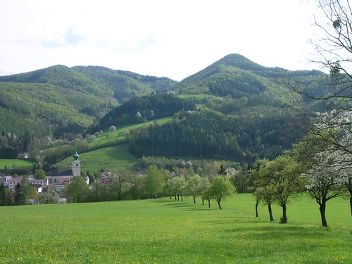
Beautiful hiking trail in interesting scenery on a small mountain near St.Veit/Gölsen, takes approximately 2,5 hours
by kybernetes
 Austria > Niederösterreich > Niederösterreich-Süd
|
|
||||
|
|||||

 Size: small
 Status: Available
 Time required: 2:30 h
 Hidden on: 04 August 2008
 Also listed at:
  1 Found
 0 Not found
 0 Notes
 1 Watcher
 0 Ignorers
 29 Page visits
 0 Log pictures

| Dangers |


|
| Route |

|
| Time |

|
| Seasonal |

|
| Persons |

|
![]() Description
Deutsch
· English
Description
Deutsch
· English
The Path...
There are various possible trails on the small, cone-like mountain near St.Veit/Gölsen. You can look them up on the community homepage(German description only).
The route preferred by the cache-owner starts at the local "stone garden" (N 48° 02.547 E 015° 40.134) and follows the so-called "nature experience trail". A guide booklet, which describes its geological und botanical characteristics, is available for 2,5 € at the municipal office opposite the church. (Opening times on the homepage)
Follow the trail behind the stone garden’s wall and cross the bridge at the small electric utility (marked blue). Keep right at the chapel to enter the "Brillergraben". If you want to visit the Staff hut first, you can turn right above the last farm and follow a red marked trail. Stay on the graveled path for the "nature experience trail" and pass the first rock formations, which mark the beginning of the Northern Limestone Alps. For the very last part of the trail, leave the blue-marked path(leading to Lilienfeld, "Via Sacra") and follow the red-marked path to the summit. This way first leads you around the summit, then to a right turn-off onto it. Take the same way down, enjoy the view while crossing the "Staff meadow" (for the summit is wooded) and think about a stop at the near Staffhütte (open on weekends).
The descending path ends at the local sports utilities near the starting point.
The Particularities..
There are some regional particularities which are worth paying attention to: St.Veit is located at the border between the sandstone zone of the Vienna Woods and the Northern Limestone Alps. The rock formations you can find on your way to the Staff already mark the beginning of the alps. The stone garden shows examples of all the valley’s different rock masses.
Thanks to the limestone layers, Christmas roses are a common sight in early spring time; the mountain is also known for some rare orchids growing here. Many of them are under nature protection, so please don’t pick any flowers along the trail. At the top you probably notice remains of walls and moats; Actually there was a castle on the summit in medieval times. It was built around 1100, but destroyed 1202 after the territory fell to the House of Babenberg.
Please note..!
Especially the last part of the path is steep and slippery when wet, you are generally advised to use good footwear and watch your step. Also, pay attention to the steep precipice on the top -don’t let your children get too close to it.
The Cache is NOT anywhere near the precipice, and it’s absolutely not necessary to take any dangerous actions in order to find it.
 Additional waypoints
  Convert coordinates
|
N 48° 02.547' E 015° 40.134' |
Steingarten St.Veit (Startpunkt); Parkmöglichkeit: über die Brücke |

 The additional waypoints are shown on the map when the cache is selected, are included in GPX file downloads and will be sent to the GPS device.
![]() Additional hint
Additional hint
![]() Decrypt
Decrypt
Haqre gur ebbgf bs n gerr ng gur rqtr bs gur pnivgl
A|B|C|D|E|F|G|H|I|J|K|L|M
N|O|P|Q|R|S|T|U|V|W|X|Y|Z
![]() Pictures
Pictures
![]() Utilities
Utilities
 Search geocaches nearby:
all -
searchable -
same type
Search geocaches nearby:
all -
searchable -
same type
 Download as file:
GPX -
LOC -
KML -
OV2 -
OVL -
TXT -
QR-Code
When downloading this file, you accept our terms of use and Data license.
Download as file:
GPX -
LOC -
KML -
OV2 -
OVL -
TXT -
QR-Code
When downloading this file, you accept our terms of use and Data license.
![]() Log entries for Staffgipfel - Staff summit
Log entries for Staffgipfel - Staff summit
![]() 1x
1x
![]() 0x
0x
![]() 0x
0x
 22 October 2022
Wandervogel 510
found the geocache
22 October 2022
Wandervogel 510
found the geocache
Bei einer Wanderung hier vorbei gekommen und das Doserl gehoben. Bis ich das Logbuch zum signieren heraus brachte dauerte es länger, da ich kein entsprechendes Tool dabei hatte.