| Langue : |


|
Pays : |


| Suivez-nous : | |||
| Contact us: | |
| Rejoignez les discussions : | ||||
|
|
Forum d'Opencaching | |||

|
Groupe Facebook | |||

|
GitHub | |||

|
Slack | |||

 Grèce
Grèce
|
|
||||
|
|||||


 Taille : petit
 Statut : disponible
 Temps nécessaire : 5:00 h
 Caché en : 04. août 2009
 Aussi listé au :
  3 trouvé
 0 pas trouvé
 0 Remarques
 0 Observateurs
 0 Ignoré
 193 Visites de la page
 1
1 

| Dangers |

|
| Infrastructure |


|
| Itinéraire |


|
| Waypoints |

|
| Temps |

|
![]() Description
English
(Anglais)
Description
English
(Anglais)
The summit of Gigilos (1.980 m) is probably the most popular mountain walk in West Crete
The reasons for this are clear:
- This is the most accessible summit walk. You just get yourself to the entrance of the gorge of Samaria and the path upwards starts there.
- The summit is probably the most impressive looking in Crete.
- The views along the walk and from the summit are superb, embracing both the Aegean sea, the north coast of the island and the Libyan Sea to the south. You also get a good bird's eye view of the Samaria gorge and can see the summits of the central Lefka Ori (White Mountains) to the east.
- The path has been substantially improved some years ago (at least two thirds of the way) and makes the walk much easier than it used to be.
The walk can roughly be divided into three parts, the return is by the same route and the total walking time is approximately 5 to 6 hours.
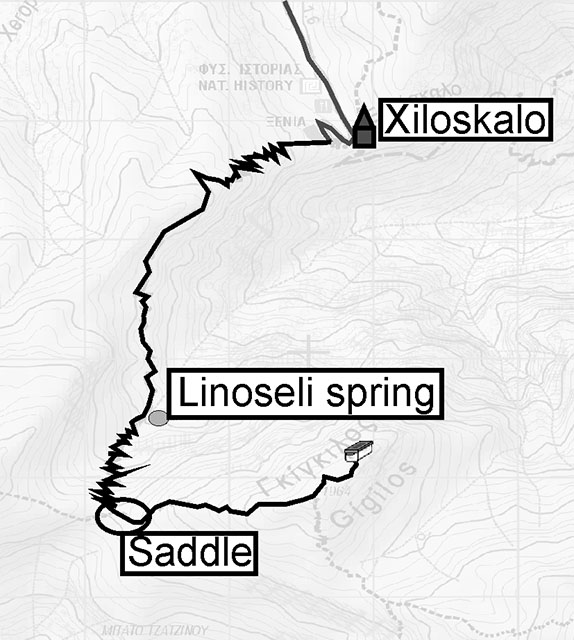 Part 1
The walk starts right next to the cafe located above the entrance
of the Samaria gorge and you first climb steadily on a good path
for about 30 minutes until the path levels off. Then the path is
more or less flat or even going down for the next 30 minutes, first
passing through ancient cypresses then a large arch and interesting
formations until it climbs up a little bit again and you get to the
spring of Linoseli. The spring water is superb and it is the only
water on the way.Part 2
Now you enter a world of stones and rocks. This is a zigzag climb (still on a good path) to the saddle, at an altitude of 1.700 m. It will take you 30 to 45 minutes. When you arrive at the saddle, you are at the entrance of the imposing gorge of Tripiti and have great views of the Libyan Sea, the island of Gavdos as well as some views of the north coast. On some days it can be very windy from that point onward (the first two parts of the walk are well protected from the wind).Part 3
The route from there to the summit is steeper and it is not really a path but a marked route (red spots and some cairns). Many people choose not to go to the summit because the last part takes more walking experience than the walk to the saddle. Still it looks more difficult than it is. The very start is the steepest part and leads past a large hole. Avoid getting too near to it as this cave starts with a vertical shaft 150 meters deep and two people have already fallen in it. Keep following the red spots (sometimes there are several routes marked but don't worry, they all lead to the summit).Often, people walking up think that they are going to have great difficulties coming back down again, but the rock (which looks like granite but is limestone) is very solid and stable underfoot. You will have to use your hands in a few places though.
The way to the summit takes approximately 45 to 60 minutes from the saddle. Once you arrive at the summit with its large stone pyramid you will notice that there is a second – even higher – summit with kind of a cross a little further on. That is the place where you want to go!
To locate the cache, look from the summit to the southeast (towards the peak of Volakias – 2.116 m) and you will spot a noticeable rock formation (see spoiler photo!) at a distance of about 10 metres. At its base you will find a lock'n'lock box hidden under some stones. Please rehide well!
Some words of warning
Gigilos is one of the first mountains to the west of the Lefka Ori (White Mountains) and weather changes can happen very suddenly (bad weather generally comes from the west). Whilst the walk to the saddle presents no problem in bad weather and poor visibility, high winds and fog from then on are extremely dangerous. In case of bad weather return immediately and as quickly as possible to the saddle. Do not attempt to walk to the summit if there is snow, even in good weather unless you are experienced and know the route well. The walk to the saddle in early spring can also be snowed in in parts and could be dangerous because there are some passages with steep drops where you cannot afford to slide down.On the walk down, people often get tired legs and knees (it is a long descent) and have to pay special attention not to stumble in the last part of the walk. Although the path is well marked it is stony. (Text in parts courtesy of www.sougia.info)
![]() Images
Images
![]() Utilités
Utilités
 Chercher des géocaches prés:
tous -
trouvable -
même type
Chercher des géocaches prés:
tous -
trouvable -
même type
 Télécharger en fichier :
GPX -
LOC -
KML -
OV2 -
OVL -
TXT -
QR-Code
Télécharger en fichier :
GPX -
LOC -
KML -
OV2 -
OVL -
TXT -
QR-Code
 Lors du téléchargement de ce fichier, vous acceptez nos conditions d'utilisation et la licence de données.
![]() Logs pour Gigilos – 1.980 m
Logs pour Gigilos – 1.980 m
![]() 3x
3x
![]() 0x
0x
![]() 0x
0x
 23. septembre 2021, 10:39
sams44
trouvé la géocache
23. septembre 2021, 10:39
sams44
trouvé la géocache
Sehr gerne logge ich auch diesen OC, so weit südlich hatte ich sicher noch keinen - Danke fürs Paralell-"Universum" ...!
The Gigilos was planed in my travel-agenda for today, and that was a fortune, as the Gorge of Samaria was closed for today because of the weatherforecast (at least the gorge stayed dry abd almost sunny - I had to longer breaks on my way to the summit for waiting that the nozzling rain will stop...).
100m before arriving at the first summit (the minor-summit) clouds disapered and the blue sky came out for all the rest.
Lots of interessting Spots and landscape were to see on that hike and the walk through the stone-layrinth to the main-summit was a nice experence to!
And of corse to interrupt the great views in all directions to find the cache up here!
TFTC & FP in
from sams44 !
Gigilos Hauptgipfel

29. avril 2018, 14:37
TofLaBeuze
trouvé la géocache
A great hike ! Beautiful landscapes during 7h. The last part of the summit was a bit hard but the health is here :)
The box is in good state.
Efkaristo ! Thanks for this opencache !
[Géocaching par Tof](https://tofgeocaching.wordpress.com/sommaire/)
[Forum: Atelier Mystery / ](http://france-geocaching.fr/forum/viewforum.php?f=99)[Aide Wherigo / ](http://france-geocaching.fr/forum/viewforum.php?f=87)[Sorties groupées / ](http://france-geocaching.fr/forum/viewforum.php?f=104)[Challenges](http://france-geocaching.fr/forum/viewforum.php?f=102)
30. mai 2014
luxi
trouvé la géocache
It was a great walk and I enjoyed the Gigilos scenery very much. And honestly, I wouldn't have walked to the second summit if there were no cache. Thanks for hiding!
Log entry copied from Geocaching.com