| Language: |


|
Country: |


![]()
 Germany > Bayern > Erding
Attention! This Geocache is "Archived"! There is no physical container at the specified (or to be determined) coordinates. In the interest of the place it should not be necessarily to search!
|
|
||||
|
|||||


 Size: no container
 Status:
  Hidden on: 29 March 2010
 Also listed at:
  10 Found
 0 Not found
 0 Notes
 1 Maintenance log
 0 Watchers
 0 Ignorers
 1099 Page visits
 4
4 

| Infrastructure |

|
| Waypoints |

|
| Time |

|
| Seasonal |

|
| Tools needed |

|
| Preparation needed |


|
| Persons |

|
![]() Description
Deutsch
· English
Description
Deutsch
· English
![]() English Version [Deutsche
Übersetzung oben]
English Version [Deutsche
Übersetzung oben]
Geographical overview of the Isen
valley
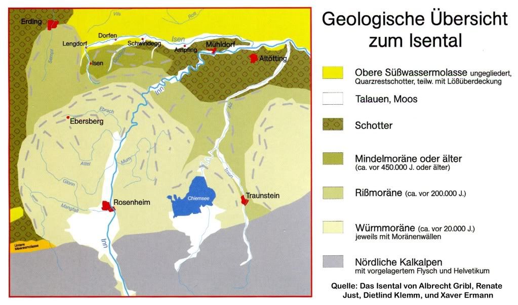 |
Over 1.8 million years
ago the first glaciers developed in todays alps. While the ice
masses grew, they moved towards the higher bavarian foreland of the
alps. In the mountains, the glaciers shaped the valleys. The
resulting detritus settled after the melting as ground morain in
the foreland.The farest reaching glaciers origin from the Mindel
period (450.000 years ago) and the Riss period (200.000 years ago)
up to south of Erding.
|
| The glaciers from the Würm period (20.000 years ago) did not reacht this far, but as the last in this region, they left the moraine tract which can be seen today together with the staggered forms of former periods. |
Course of the
Isen
| The course of the Isen is associated with the geological borders. The molasse spreds in the noth of the glacier region up to the Danube - a dip in front of the rising alps, which gathered the detrius that was driven there by the rivers. It covers the molasse in the aereas of Erding and the valleys of Isar and Inn. Following the course of the Isen, you draw the line of the northern border, running east to west, of the glaciers approach of the last period against the molasse. This may be visible especially between Lengdorf and Schwindegg. In widely formed loops, the Isen may meander east of Schwindegg. Here the river seperates the detrius and the molasse. South of Lengdorf, the Isen incised straight through the moraine. | 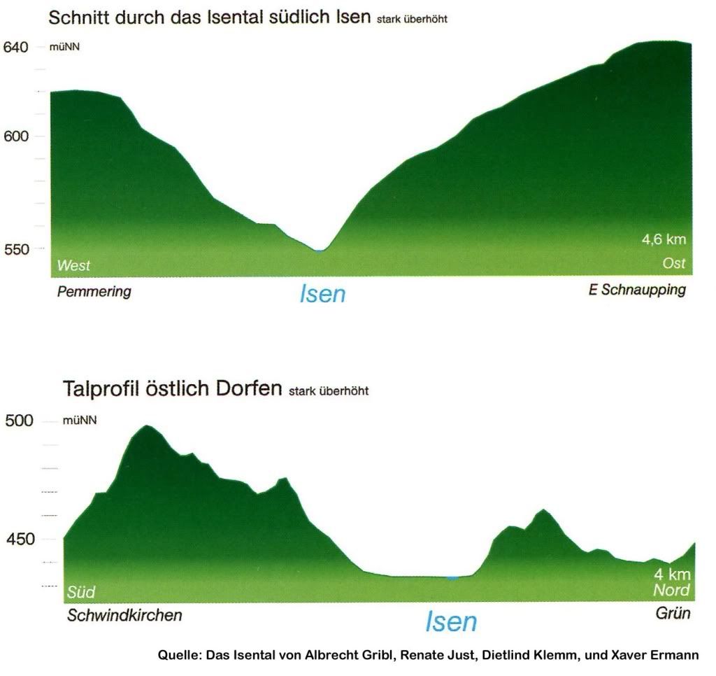 |
Exceptional zoological and biological
enviroment
| Fens, backwaters, meadows and marches - due to it's multifarious appearance, the Isen valley is home of many endagered species. The very amount of 66 different kind of birds, like the bluethroat, th ecurlew or even the rare kingfisher may be observed. You may find the egret, white- and black storks. The steeple of Schwindenkirchen is refuge of the greater mouse-eared bat, beavers build dams in the course of the Isen and clams live on it's ground. Despite of many rearrangements of the natural course by human hand, the Isen is still having an abundance of freshwater fish - as one of the last in Bavaria. |
|
|

Cacheinfo
| Next to the "Lindumer Kircherl" the "Schwammerl" is located. In former times he was a beloved meetingpoint for couples. Today he is a symbol of protest against the construction of the motorway A 94 in the Isen valley. |
|
Questions
Requirements to log:
|
![]() Utilities
Utilities
 Search geocaches nearby:
all -
searchable -
same type
Search geocaches nearby:
all -
searchable -
same type
 Download as file:
GPX -
LOC -
KML -
OV2 -
OVL -
TXT -
QR-Code
Download as file:
GPX -
LOC -
KML -
OV2 -
OVL -
TXT -
QR-Code
 When downloading this file, you accept our terms of use and Data license.
![]() Log entries for Isental
Log entries for Isental
![]() 10x
10x
![]() 0x
0x
![]() 0x
0x
![]() 1x
1x

 01 September 2016
dogesu
has archived the cache
01 September 2016
dogesu
has archived the cache
Das letzte Funddatum liegt lange zurück und die Logs bei geocaching.com (GC25TV6) besagen, dass die Infotafel, die zur Beantwortung der Fragen nötig ist, nicht mehr vor Ort ist. Aus diesem Grunde archiviere ich ihn auch hier. Sollten sich später neue Aspekte ergeben, so kann dieses Listing durch den Owner selbstständig über ein "kann gesucht werden"-Log reaktiviert werden.
dogesu (OC-Support)
 06 December 2015, 16:27
leni1811
found the geocache
06 December 2015, 16:27
leni1811
found the geocache
das ISENTAL - es lässt sich mittlerweile schwer vorstellen wie schön und romantisch es hier mal war
aber heutzutage wartet man halt sehnsüchtig auf die Fertigstellung der Autobahn und so ist es halt der Lauf der Zeit, dass auch so ein angesagter Treffpunkt wie der Schwammerl nicht mehr vorhanden ist - obwohl wir erfuhren, dass dieser vielleicht sogar wieder aufgebaut werden könnte, da er im Bauhof eingelagert ist - wir werden sehen
an diesem schönen sonnigen Nikolaustag konnte nun endlich dieser EC abgearbeitet werden
vielen Dank an Lady_Biene für die Ausarbeitung und Pflege dieses EC und die gute Idee genau an dieser Stelle uns ins Isental zu locken
19 April 2015
goregas
found the geocache
Der
Baufortschritt ist unübersehbar und die Spaltung der Landschaft jetzt
schon deutlich spürbar. Der Vergleich der Fotos von den vergangenen
Monaten ist einfach nur erschreckend. Der Pfad ist nun auch teilweise
abgesperrt, da der Hang stückweise nachgibt. Dass das Schwammerl weg
ist, wurde ja schon gepostet.
Die Mail mit den Antworten wurde an die Owner geschickt und hier im Listing hängen wir noch Fotos an.
Danke fürs Herführen und Gruß an Lady_Biene.
Schwammerl!

08 September 2012
TeamPuck
found the geocache
Als "Fast-Abschluss" unserer heutigen Tour haben wir noch diesen EC besucht.
Eine wirklich schöne "Aussicht" war das heute, schon schade, dass die A94 hier wohl in absehbarer Zeit so einiges "verändert" :-(
Die Antworten auf die Fragen gehen dem Owner durch das Team um aljoma zu, ein Foto hänge ich selbstverständlich an!
Danke für diesen EC!
TFTC #2671!
08 February 2012
Barkley
found the geocache
Nette Aussicht über
all die in der Wintersonne glitzernden Mais- und Rapsfelder. Mit dem
Relikt hatte ich so meine Probleme, weil die Schnee- und Eisschicht
nähere Infos nicht erlaubten. Ich hoffe mal, es passt trotzdem ![]() .
.
Danke für den netten Cache.
Am Schwammerl
