| Lingua: |


|
Nazione: |


Andritzer Plattenrunde
11km hike from Andritz to Platte (651m) and back. Elevation change 300m, ascend/descend 370m.
di aj-gps
 Austria > Steiermark > Graz
|
|
||||
|
|||||


 Dimensioni: piccola
 Stato: disponibile
 Nascosta il: 22. marzo 2008
 Pubblicata anche su:
  14 trovata
 0 non trovata
 1 Nota
 2 Osservata
 0 Ignorata
 159 Pagina visite
 4
4 

![]() Descrizione
Deutsch
· English
(Inglese)
Descrizione
Deutsch
· English
(Inglese)
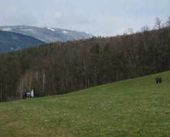
This cache leads from the heart of Andritz, the 12th district of Graz, to the top of the Platte, a 651 meter high rise north-east of the city.
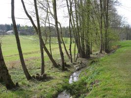
The route consists of paved roads with hardly any traffic, forest roads and trails along meadows and through forestal areas.
Even though this cache follows existing hiking trails on some parts of the route I still hope to be able to show something new to a few visitors.
If you want to look up the route on a map: Zelinkagasse - Ursprungweg - Rotmoosweg - Radegunder Strasse - Weizbachweg - #85a - "Koller" - 2. Plattenkreuz - Stephanienwarte - Plattensteig - 1. Plattenkreuz - Oberer Plattenweg - #85 - Pfeifferhofweg - Im Vogelsang - Pfeifferhofweg - Zelinkagasse
For some it might be possible to do this cache by bicycle but note that on some parts of the route it's not allowed to ride a bike.
The drive-in department might be interested to know that all questions that need to be answered are located at places where reaching them by car is either impossible, forbidden or all in all will take longer than walking the tour.
Nearby caches
It would make sense to take a print-out of Memory I oder Plattenwandertag (GCMBY2) and Stephanienwarte (GC1AE0C) with you if you haven't already found these two caches. While the latter is right next to this caches' route the first one requires a small detour.
Approach
The header coordinates are close to the bus and tram station "Andritz" which can be reached by public transport with tram lines 4 and 5 and bus lines 41, 52 and 53.
By bike the header coordinates are easily reachable by first following the R2 Murradweg and then the "Andritz" bikeway signs.
For cars there are some parking lots at the given parking coordinates (N47°06.157 E015°25.402). There are usually no cars there on weekends but during the week it might be necessary to look for an alternative parking location.
Route
At the header coordinates follow the street leading north-east until you reach the Schoeckelbach creek. There follow the bikeway (without crossing the creek) until you reach a street with a crosswalk (Rotmoosweg; WP1; N47°06.744 E015°25.510). To your left you see the Johanneshof, but we turn right and follow the street uphill. At a traffic light cross the street, but don't continue along the marked trail #85a. Instead follow the street a few meters to the south and then turn left (Weizbachweg; WP2; N47°06.602 E015°25.844).
First question - Q1 (N47°06.794 E015°26.754): How many mailboxes (for different households) are here? Result: A
At WP3 (N47°06.788 E015°27.407) keep left.
Second question - Q2 (N47°06.987 E015°27.370): At the A-shaped power pole you will find two small tags. One which is right above another small tag of the same size contains a letter and some digits - we are interested in the digits. Result: BC
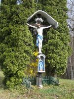
Follow the street through the homestead. There is a nice cross right after it on the right side.
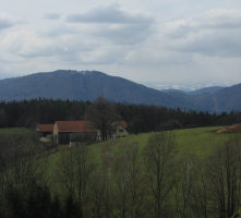
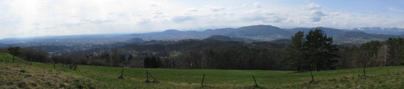
WP4 (N47°07.152 E015°27.452) offers a nice view.
Update Jan 2016: The paths in this area have changed in the last years as one is no longer allowed to walk by some nearby houses. From WP4 walk a few meters to the north and then follow the path into the forest towards Q3 (coordinates below). This used to be trail #85a which now bypasses the private area after Q3 on the south side.
Third question - Q3 (N47°07.254 E015°27.708): Number of letters of the last name of the person that died here. Result: D
Update Jan 2016: After Q3 please don't follow the old #85a trail that would go into now private property. Instead try to find a path leading south where you will reach the current (new) #85a that goes around the private area.
You will soon reach a street crossing. If you haven't found "Memory I oder Plattenwandertag" (GCMBY2) yet and have time for a small detour it would make sense to go for that cache. Otherwise keep on trail #85a until you reach the Stephanienwarte (WP5; N47°06.756 E015°28.173). If you haven't found "Stephanienwarte" (GC1AE0C) yet.. well you know.
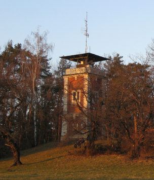
Fourth question - at WP5 (N47°06.756 E015°28.173): On the outside above the entrance portal (not next to the locked door inside!) you will find a plate with four lines of text. How many words are on the 3rd line? Result: E
(Note: It does not matter how you would write it, I am referring to the number of words on the plate)
Update Jan 2016: Since 2010 the tower is now open to visitors in summer on holidays and weekends from 10-19h.
Follow trail #85 downhill towards WP6 (N47°06.680 E015°28.096) which offers another nice view.
Update Jan 2016: The inn is closed since quite a while.
People who are hungry or thirsty can then visit Buschenschank Erart (Fri-Sun 14-22; N47°06.543 E015°27.799) and then continue on trail #85.
Note that the trail leaves the street at WP7 (N47°06.447 E015°27.479)!
Fifth question - Q5 (N47°06.451 E015°26.540): To your left you will see an unexpected object in some distance. It's (Result F): 2-blue, 5-silver, 7-gold, 9-red.
Update Aug-24-2008: Note that if you don't see the object due to vegetation take the next street to your left and follow it for a few meters.
You can use the nearby bench to calculate the final coordinates.
N47°06.E(B-2)(A+3)
E015°26.C(D-1)F
WP8 (N47°06.450 E015°26.437): Leave the street and follow the unmarked trail to your left into the forest.
WP9 (N47°06.344 E015°26.045): Leave the forest, follow the street downhill. At the next crossing go left, downhill. Then continue towards the header coordinates.
![]() Suggerimenti addizionali
Suggerimenti addizionali
![]() Decripta
Decripta
Ynetr orrpu gerr
A|B|C|D|E|F|G|H|I|J|K|L|M
N|O|P|Q|R|S|T|U|V|W|X|Y|Z
![]() Utilità
Utilità
 Visualizza le raccomandazioni degli utenti che hanno raccomandato questa geocache: all
 Cerca geocache vicine:
tutte -
ricercabile -
stesso tipo
Cerca geocache vicine:
tutte -
ricercabile -
stesso tipo
 Scarica come file:
GPX -
LOC -
KML -
OV2 -
OVL -
TXT -
QR-Code
Scarica come file:
GPX -
LOC -
KML -
OV2 -
OVL -
TXT -
QR-Code
 Scaricando questo file accetti i nostri termini di utilizzo e la Licenza dati.
![]() Log per Andritzer Plattenrunde
Log per Andritzer Plattenrunde
![]() 14x
14x
![]() 0x
0x
![]() 1x
1x

 19. gennaio 2020, 15:05
bogota
ha trovato la geocache
19. gennaio 2020, 15:05
bogota
ha trovato la geocache
Schöne Runde :-)
TFTC
23. aprile 2014, 16:00
na6azemlia
ha trovato la geocache
Eine wirklich schöne Wanderung, kannte ich noch nicht. TFTC!
07. ottobre 2010
xro
ha trovato la geocache
Als wir ein paar Stunden zuvor noch, uns mittene bei einem Bacherl-Cache erwischt hat und wir ihm erzählten wir wollten heute noch die Andritzer Plattenrunde machen, hat er uns ein wenig ungläubig angeschaut. Immerhin es war schon eindeutig Nachmittag und das Wetter verhieß Regen. Aber, war wir uns vorgenommen haben, wird auch durchgezogen. Ein paar Caches später also es endlich zur Q1 geschafft. Spätestens zw. Q2 und Q3 hatte uns dann wirklich und endgültig der Platzregen und Sturm eingeholt, doch dafür war ich ja ausgerüstet: Regenhose und Regenjacke. So ging's am Mountainbike auf Wald- und Forstwegen rauf bis zur Platte. Runter war's dann vergleichsweise schon fast gemütlich  Nur am Weg vom komischen Objekt zum Final hat es Pelzwechsler kurz aber voll über eine Wurzel aufgestellt. Da hat man wieder gesehen, Training hilft offensichtlich, denn: keine einzige Schramme.
Danke für diese tolle Erlebnisrunde, nach welcher wir uns das Abendessen redlich verdient hatten :-)
TFTC
P.S.: Nach dem Regen betrug der Wasserstand in der Dose sicher 2mm. Dose hatte aber keine offensichtlichen mechanischen Fehler. Sind die Teile doch weniger dicht als gedacht ?
19. aprile 2009
stinknormal
ha trovato la geocache
Waren heute bei anfangs gutem Wetter auf der Suche nach dem Chache! Sehr schöne Runde, die wir mit dem Rad erledigt haben! Einziger Wehrmutstropfen, eine verlorene Jacke... Allerdings wiedergefunden, nach rückwärtigem Aufstieg zum Cache...
Quasi gleich 2 Funderlebnisse an einem Tag!
Eine wirklich schöne Runde, die wir ohne diesen Cache wahrscheinlich nie gemacht hätten!
TFTC
 08. dicembre 2008
ferret out
ha trovato la geocache
08. dicembre 2008
ferret out
ha trovato la geocache
Wurde bei strahlendem Sonnenschein mit einer herrlichen Aussicht belohnt. Dank der exakten Beschreibung ganz ohne Umwege gefunden.
TFTC
26. ottobre 2008
divingbrothers
ha trovato la geocache
Gemeinsam mit harrylime und Mama und Papa hab ich heute diese Runde absolviert. in:TB TFTC
Aufgrund des Wetters gabs leider keine Aussichten,aber es war trotzdem eine nette Wanderung.
24. agosto 2008
Möwe
ha trovato la geocache
Very nice bike tour together with aj-gps.
It was, at some stages, exhausting for me but in the end I managed to solve all questions.
Very nice view from the top!
TFTC
 24. agosto 2008
aj-gps
ha scritto una nota
24. agosto 2008
aj-gps
ha scritto una nota
Two minor updates in the description:
Near the viewpoint a new inn has opened one month ago. Question 5 is currently difficult to solve due to vegetation, added some information about how to find the object.
Zwei kleine Updates der Beschreibung:
Beim Aussichtspunkt hat vor einem Monat eine neue Gaststätte eröffnet. Frage 5 ist derzeit aufgrund der Vegetation schwierig zu beantworten, hier wurde ein Hinweis eingefügt wie das Objekt zu finden ist.
25. maggio 2008
orotl
ha trovato la geocache
Heute die Plattenrunde 'gedreht'.
Eigentlich war geplant dass ich den Owner mit seinem Fotografen unterwegs einhole.
Bis zur Warte rauf gelang mir das nicht, kein Wunder scheinbar hatte ich sie schon unten in Andritz durch eine kleine Abkürzung überrumpelt.
Tja, dann eben auf der Warte in Ruhe im Regenschatten auf die beiden gewartet.
Der Abstieg/Fahrt danach war richtiggehend erholsam.
Mal wieder ein paar unbekannte Wegerl kennengelernt, danke dafür und für die nette Runde.
TNLNS
13. aprile 2008
Lord Harry
ha trovato la geocache
Schöne Wanderung mit sehr netter Begleitung!
Zu viert haben wir uns aufgemacht um diesen Cache zu machen.
Fast alle Stationen wurden auch rasch gefunden. Nur WP 1+2 habe wir ausgelassen weil wir (ich) dachte es wäre anderst kürzer... Fehler! kürzer vielleicht aber auch anstrengender...
Unterwges mussten natürlich auch die Stephanienwarte und der Memory I erledigt werden!
Danke für diesen schönen Cache!
TFTC XNSL
Lord Harry
13. aprile 2008
Nikita99
ha trovato la geocache
Wie meine beiden
Vorlogger schon geschrieben haben, heute bei schönem Wetter auf die
Suche nach diesem Cache gemacht! War echt ein schöner Nachmittag und
hat viel Spaß gemacht! Wieder ein Plätzchen mehr kennen gelernt, den
ich noch nicht kannte! TFTC ;o)
Out: TB
02. aprile 2008
gebu
ha trovato la geocache
Dank der Sommerzeit gehen sich jetzt endlich wieder etwas längere After Work Touren aus. Und genau für sowas eignet sich dieser Cache perfekt.
Ein paar Abschnitte der Wanderung waren mir schon bekannt, grösstenteils gings jedoch durch mir unbekanntes Gelände.
Bei der zweiten Frage gleich mal den falschen Wert aufgeschrieben der erst durch Telefonjoker WW (danke dafür!) korrigiert werden konnte.
out: gc
[This entry was edited by gebu on Sunday, April 06, 2008 at 12:35:19 PM.]
Schatten

Licht

Feuer & Wasser

Frühling

31. marzo 2008
JulieWood_Rabat
ha trovato la geocache
Hallo miteinander diesen
Cache als Staffellauf gemacht. Bei WP5 haben Katharina und Angi auf
Martin gewartet und dann ging es ein Stück gemeinsam weiter. Endlich
wieder einmal ein etwas längerer Schöner Cache im Grazer Gebiet. TFTC In: TB Angi, Katharina & Martin
30. marzo 2008
Rhodo Dendron
ha trovato la geocache
Optimale Tour für einen wunderschönen Frühlingssonntag wie diesen.
TFTC NT
27. marzo 2008
cezanne
ha trovato la geocache
As expected we could not find a place to leave my car at the suggested parking coordinates. We were more lucky near the church at Geisslergasse.
Due to the precise description and my knowledge of the area, we had no problems to find the right route despite the fact that we had been much too lazy to enter all waypoints into our GPS-r.
While Stages 1-3 have never before attracted my attention, Stages 4 and 5 were well known to me and I even knew in advance which places where meant when I read the description.(So the object at the Stage 5 was not surprising at all for me.)
It was a very nice walk. In the first part the weather was sunny and warm. In the summit area of the Platte it started to drizzle.
After having assembled the coordinates at the bench close to Stage 5, we approached the cache. Due to Alice's very precise GPS-r, we found the cache very quickly. This time I was the first at the cache, but only because Alice had offered me her GPS-r.
Thank you for hiding this nice cache which invites for an extended walk in a nice area of Graz.
Out: TB Olaf's Dog
GC Punktegeier Geocoin V1.0
In: TB Petzi