| Language: |


|
Country: |


![]()
Rauris #1: Goldspuren / gold traces
along the traces of gold and up to the
by K2MO
 Austria > Salzburg > Pinzgau-Pongau
Attention! This Geocache is "Locked, visible"! There is no physical container at the specified (or to be determined) coordinates. In the interest of the place it should not be necessarily to search!
|
|
||||
|
|||||


 Size: normal
 Status:
  Hidden on: 21 August 2005
 Also listed at:
  3 Found
 0 Not found
 0 Notes
 1 Maintenance log
 0 Watchers
 1 Ignorers
 169 Page visits
 7
7 

![]() Description
Deutsch
· English
Description
Deutsch
· English
|
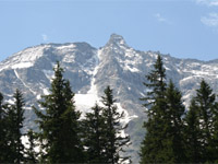
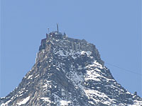
The first cache in my homelands Rauris leads along the traces of gold and up to the "Hoher Sonnblick" (3.106 m), the most famous moutain of Rauris. (more about the history of gold mining in Raurisertal) The main coordinates lead directly to the top of the Hoher Sonnblick. There is a parking area calles "Lenzanger" at N 47° 04.900 / E 012° 59.100, from where you can go to Kolm-Saigurn by feet. There is also the possibility to go there directly with the postbus. (For the street from guesthouse "Bodenaus" to the "Lenzanger" you have to pay a toll, the toll is cheaper when you go by bus.) You need about 3 to 5 hours from Kolm-Saigurn to the Hoher Sonnblick, so you´ll need a whole day for this cache, or maybe two if you´ll do it with an overnight stay. You can find other routes with more moutains and a great view to the world of mountains of Rauris by clicking here.
|
|
|
Stage 1 - Hoher Sonnblick (3.106
m) N 47° 03,238 / E 012° 57,455 A marked way leads from "Naturfreundehaus Kolm-Saigurn" to the "Neubau" (shelter), where you can find the "Tauerngold-Rundwanderweg" and a few ruines from the gold mining times to learn more about the history and the geology. The next hat is the "Rojacher-Hütte" and finally you reach the top of the "Hoher Sonnblick" (N 47° 03,238 / E 012° 57,455), where you can find the shelter "Zittelhaus" (possability for overnight stay, the sunrises are really recommandable) and the Sonnblick-Observatorium, the highest weather measuring station of Europe. At stage 1 you can find a few boards about the weather men in the vestibule of the "Zittelhaus", the board of Mathias Mayacher was mounted in September ?, the digit sum of the year is A. On the board of Albert Obermayer the difference of the two years in the first line is the number B. (positive number)
|
|
|
|
Stage 2 -
Kolm-Saigurn N 47° 04,044 / E 012° 59,086 Either at the next morning after a great sunrise or on the same day you have to go back down to Kolm Saigurn, where you will find the cache. At the coordinates of stage 2 you will find a board about the shelter "Neubau". There you can find one number twice on this board, this is the number C, and in the last line on the right side there is an altitude of another mountain, the digit sum of this altitude is the number D. |
|
|
For calculating the cache
coordinates: The cache, a green plastic box, is
at the caculated coordinates on the right side of the prominent
symbol. Would you please bring a biro with you, I think I´ve
forgotten to put into the box... Please rate the cache: | ||
![]() Pictures
Pictures
![]() Utilities
Utilities
 Search geocaches nearby:
all -
searchable -
same type
Search geocaches nearby:
all -
searchable -
same type
 Download as file:
GPX -
LOC -
KML -
OV2 -
OVL -
TXT -
QR-Code
Download as file:
GPX -
LOC -
KML -
OV2 -
OVL -
TXT -
QR-Code
 When downloading this file, you accept our terms of use and Data license.
![]() Log entries for Rauris #1: Goldspuren / gold traces
Log entries for Rauris #1: Goldspuren / gold traces
![]() 3x
3x
![]() 0x
0x
![]() 0x
0x
![]() 1x
1x

 14 June 2017
dogesu
has locked the cache
14 June 2017
dogesu
has locked the cache
Der Benutzeraccount wurde deaktiviert.
 29 August 2008
npg
found the geocache
29 August 2008
npg
found the geocache
Sonnige Aussichten bis zum Gipfel frühmorgens als ich mit meinem Vater gen Sonnblick aufbroch.
Bis Neubau hielt sich das sonnige Wetter auch noch, aber bei der Ankunft an der Rojacher wars schon nebelverhangen.
Gar nicht ungefährlich heute: Bei der Rojacherhütte kam gerade ein Wanderer zur Verarztung, welchen es am vereisten Schneefeld einige Meter abgeworfen hatte (Prellungen, Schürfwunden- aber er konnte einbandagiert absteigen). - Tja, mir wäre eh ein Auf/Abstieg über den schneefreien Grat lieber gewesen, aber mein Vater wollte den Grat lieber nicht abklettern.
Aber alles heil geblieben [:D]..und kaum im Tal war auch die Warte (ab und zu zumindest) wieder zu erspähen.
thx npg - tolle Gegend, auch wenn der Berg seinem Namen nicht ganz gerecht wurde [:)]
[This entry was edited by npg on Friday, August 29, 2008 at 2:21:24 PM.]
Nebellose Nachbarschaft

Barbarawasserfall

Wegweiser

Frühmorgens ist die Welt noch sonnig

11 August 2008
Gavriel
found the geocache
Dem Doserl gehts gut, nichts getauscht. Für einen TB war uns die Besuchsfrequenz zu unsicher.
Ein ziemlicher Blasius ist heut gegangen, aber es hat noch ausgehalten. Hoffentlich merkt das Wetter nicht, dass wir hier sind ![]() .
.
thx, Gavriel & Mike
29 August 2005
Ghost62
found the geocache
Haben heute den Sonnblick wie immer von der kärntner Seite erklommen, sind dann aber erstmals ins Rauriser Tal abgestiegen. Der Grund war klar - aber nicht nur wegen des FTF sondern auch wegen der schönen Gegend hat sich die Tour gelohnt! Die Koordinaten waren sehr präzise. Ohne Hintfoto würden wir aber wahrscheinlich immer noch suchen. Out: Stein aus Kalifornien
In: Gummiball
Sonnblick 001

Sonnblick 002

Sonnblick 003
