| Sprache: |


|
Land: |


- Auswahl
- Suchen
- Verstecken
- Beschreibung
- Erlaubte HTML-Tags
- Meine Caches
- Empfohlene Caches
- Cachelisten
- OConly-81


 Rumänien > Sud-Est > Buzău
|
|
||||
|
|||||


 Größe: kein Behälter
 Status: kann gesucht werden
 Versteckt am: 12.10.2013
 Auch gelistet auf:
  0 gefunden
 0 nicht gefunden
 0 Bemerkungen
 0 Beobachter
 0 Ignorierer
 60 Aufrufe
 0 Logbilder

 Cachelisten
| Infrastruktur |

|
| Zeitlich |

|
![]() Beschreibung
English
Beschreibung
English
![[RO]](https://s3.amazonaws.com/gs-geo-images/15da3ee9-51aa-495f-9df5-51b998cf3b4e_l.png) Acest Pământ-cache vă va arăta vulcanii noroioși de la Berca. În România se cunosc mai multe locuri cu vulcani noroioși, cel din valea Berca-Arbănasi fiind cel mai extins [1]. La Berca o suprafață de 30 km2 în jurul vulcanilor noroioși a fost declarată rezervație naturală în 1924. Aici există două zone învecinate cu vulcani noroioși și anume Pâclele Mari (coordonate de mai sus) și Pâclele Mici (N 45 ° 20.350 E 026 ° 42.500).
Acest Pământ-cache vă va arăta vulcanii noroioși de la Berca. În România se cunosc mai multe locuri cu vulcani noroioși, cel din valea Berca-Arbănasi fiind cel mai extins [1]. La Berca o suprafață de 30 km2 în jurul vulcanilor noroioși a fost declarată rezervație naturală în 1924. Aici există două zone învecinate cu vulcani noroioși și anume Pâclele Mari (coordonate de mai sus) și Pâclele Mici (N 45 ° 20.350 E 026 ° 42.500).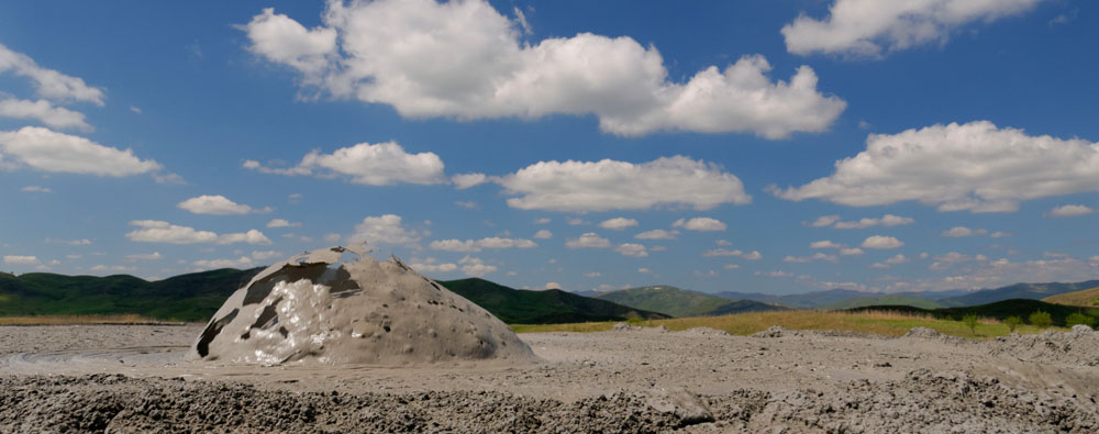 Vulcanii noroioși sunt formați prin "erupții" lente sau bruște de gaze naturale - în principal metan - care împing noroi, ape subterane și, uneori, petrol, la suprafață. Prin uscarea noroiului apar structuri asemănătoare conurilor vulcanice cu o înălțime de cîțiva metri. [2]. Se estimează [3] că vulcanii noroioși de la Berca emit aproximativ 1200 de tone de metan pe an, un gaz cu un puternic efect de seră. Gazul provine de la o adâncime de circa 3 km.
Din punct de vedere geologic, pot fi distinse două tipuri de vulcani noroioși. Un tip este asociat cu activitatea vulcanică reală, celălalt nu [1]. Vulcanii noroioși de la Berca aparțin ultimului tip. Vulcanii noroioși sunt adesea asociați fie cu regiuni geodinamic active (falii) fie cu prezența depozitelor de petrol și gaze naturale [1], sau cu ambele cum este cazul aici. Prezența unor depozite de gaze naturale în regiunea Buzăului este atestată și de un alt fenomen interesant, focuri vii.
Pentru a întregistra (log) acest cache, vă rugăm să răspundeți la întrebările de mai jos și să trimiteți răspunsurile la adresa de e-mail din profilul nostru:
1) Noroiul provenit din vulcanii este fierbinte sau rece, și de ce?
2) Cât de multe "cratere" active puteți identifica?
3) Estimați înălțimea aproximativă a celui mai înalt vulcan noroios - nu este nevoie de un răspuns precis, faceți doar o aproximație.
4) Credeți că răspunsurile la alineatul (2) și (3), vor fi la fel dacă vă întoarceți cam peste an, și de ce?
5) (opțional) Încărcați o imagine a voastră și / sau a GPS-ul vostru când înregistrați cache-ul
Puteți înregistra cache-ul de îndată ce ați trimis răspunsurile, nu este nevoie să așteptați permisiunea noastră. Dacă există probleme cu răspunsurile voastre, vă vom contacta...
![[EN]](https://s3.amazonaws.com/gs-geo-images/8076b85b-38d1-40f9-9e1f-9c73f8e73bb2_l.png) This Earth Cache will show you the Berca mud volcanoes. Several sites with mud volcanoes are known in Romania, with those here in the Berca-Arbanasc valley being the largest [1]. An area of 30 km2 surrounding the Berca mud volcanoes was declared a nature reserve in 1924. Here, two sites exist in close proximity, Paclele Mari (above coordinates) and Paclele Mici (N 45° 20.350 E 026° 42.500).
This Earth Cache will show you the Berca mud volcanoes. Several sites with mud volcanoes are known in Romania, with those here in the Berca-Arbanasc valley being the largest [1]. An area of 30 km2 surrounding the Berca mud volcanoes was declared a nature reserve in 1924. Here, two sites exist in close proximity, Paclele Mari (above coordinates) and Paclele Mici (N 45° 20.350 E 026° 42.500).
Geologically, two types of mud volcanoes can be distinguished. One type is associated with true volcanic activity, the other type is not [1]. The Berca mud volcanoes belong to the latter type. Mud volcanoes are often associated with either geodynamically active regions or the presence of oil and gas deposits [1], or both as is the case here.
In order to log this cache, please answer the questions below and send them to the e-mail adress in our profile:
1) Is the mud ejected from the volcanoes hot or cold, and why?
2) How many active "craters" can you identify?
3) Estimate the approximate height of the highest mud volcano - there is no need to be precise here, just make a guess.
4) Do you think the answers to (2) and (3) will be the same if you come back in a year or so, and why?
5) (optional) Upload a picture of yourself and/or your GPS with your log
You can log the cache as soon as you have sent the answers, there is no need to wait for a log permission. If there are any problems with your answers we will get in touch ...
Sources:
[1] V.N. Kholodov, Lithology and Mineral Resources 37(2002)197; Mud Volcanoes, Their Distribution Regularities and Genesis: 1.
[2] Wikipedia - Berca Mud Volcanoes
[3] G. Etiope et al., Terra Nova 16(2004)179; Gas Flux to the Atmosphere from Mud Volcanoes in Eastern Romania
Photos & video: own work; flags: public domain
![]() Hilfreiches
Hilfreiches
 Suche Caches im Umkreis:
alle -
suchbare -
gleiche Cacheart
Suche Caches im Umkreis:
alle -
suchbare -
gleiche Cacheart
 Download als Datei:
GPX -
LOC -
KML -
OV2 -
OVL -
TXT -
QR-Code
Download als Datei:
GPX -
LOC -
KML -
OV2 -
OVL -
TXT -
QR-Code
 Mit dem Herunterladen dieser Datei akzeptierst du unsere Nutzungsbedingungen und Datenlizenz.
![]() Logeinträge für Berca Mud Volcanoes
Logeinträge für Berca Mud Volcanoes
![]() 0x
0x
![]() 0x
0x
![]() 0x
0x