| Sprache: |


|
Land: |


- Auswahl
- Suchen
- Verstecken
- Beschreibung
- Erlaubte HTML-Tags
- Meine Caches
- Empfohlene Caches
- Cachelisten
- OConly-81


WebCam - Leadhills (OK03AE)
【ツ】 WebCam cache in Scotlands Highest Village
von GeoCacheLauget
 Großbritannien > Scotland > South Lanarkshire
|
|
||||
|
|||||


 Größe: kein Behälter
 Status: kann gesucht werden
 Zeitaufwand: 0:20 h
 Versteckt am: 20.01.2017
 1 gefunden
 0 nicht gefunden
 0 Bemerkungen
 1 Beobachter
 0 Ignorierer
 134 Aufrufe
 1
1 

 Cachelisten
| Infrastruktur |

|
| Wegpunkte |

|
| Zeitlich |

|
| Saisonbedingt |


|
| Listing |

|
![]() Beschreibung
English
Beschreibung
English
Please be aware this is a working fire station. Please do not obstruct the doors in any way and park your vehicle away from the building.
Go to the above coordinates.
You will be in front of a webcam that takes a picture every few minutes.
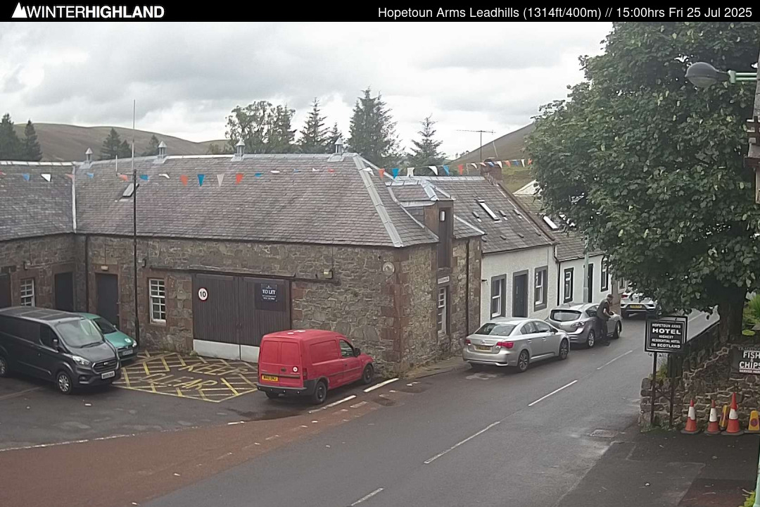
This Camera is looking out from the Hopetoun Arms Hotel along Main Street in Scotland's highest village, Leadhills.
This webcam is online 24 hours a day. Lowther Hill Ski Club run beginner rope tows on the Golf Course behind the hotel when snow permits.
Now you need someone to save the picture of yourself taken by the webcam or save it as a screenshot on your smartphone.
To log this cache, you have to post this picture.
The picture should allow to identify you as a geocacher.
How you do that is up to you:
holding up an umbrella, banners, warning vests, balloons, headlights, or cheering into the camera... all the purpose is welcome!
Leadhills, originally settled for the accommodation of miners, is a village in South Lanarkshire, Scotland, 5 3⁄4 miles (9.3 km) WSW of Elvanfoot. The population in 1901 was 835. It was originally known as Waterhead.
Leadhills is the highest village in Scotland at an average height of 1,460 feet (450 m) above sea-level. All local road signage will tell you that the neighbouring village of Wanlockhead is the highest village in Scotland. However, the Ordnance Survey are currently re-measuring the height of the village and neighbouring Wanlockhead as the method used to place Wanlockhead higher than Leadhills is no longer used and Wanlockhead is the lower of the two villages by some 20 meters or more.
Leadhills experiences a subpolar oceanic climate (Cfc). Due to its elevation and inland position, winters are colder and summers cooler than lower lying areas. In terms of the local climate profile, given its elevated position and latitude, Leadhills is amongst the coldest places in the British Isles. In fact, according to the most recent 30-year climate period of 1981-2010 Leadhills is the coldest village in the UK (of those with weather stations) with an annual mean temperature of 6.76 °C (44.17 °F) making it slightly colder than the commonly regarded coldest settlement of Braemar, which had an annual average temperature of 6.81 °C (44.26 °F) in this period. However, Leadhills' slightly more exposed and elevated location than Braemar results in absolute minima being higher than one might expect - the December absolute minimum of −15.0 °C (5.0 °F) compares favourably to usually milder Glasgow Airport's absolute minimum of −20.0 °C (−4.0 °F). Winter snowfalls can be heavy, with falls often exceeding 30 cm, and due to the exposed location can be whipped into deep drifts often closing the main road through the village for a while.
The Cache:
This is a new webcam and the only one in the village (There are two higher webcams near the radar station but these are off grid and not reliable). To claim a find you simply have to attach a photograph with your log showing you stood on the hatched area outside the Fire Station (See image). However, here is the twist:
There is little to no mobile phone signal in Leadhills (patchy 2G via EE only), and so there is no internet connection. So to obtain your photograph you will need a friend to be at a computer at an agreed time. The friend can then capture your image for you.
The webpage image does not refresh automatically and so your friend needs to refresh every 5 to 6 minutes. So you may have to stand around for a while hoping that your friend has captured you!
The website to get the image from is http://www.winterhighland.info/cams/lowtherhill/
Owner: N0hope => OC.UK/OK03AE
Lowther Hill Summit
This webcam is 'off the grid' and persistent dull conditions may mean a lack of power.
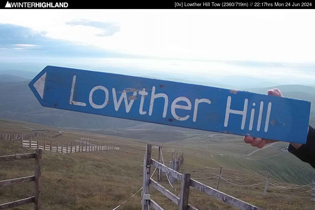
Lowther Hill Tow & Throw Rig.
First image approx. 08.04hrs.
Last image at 16.20hrs.
This Camera is situated close to the summit of Lowther Hill, the highest point on the Southern Upland Way and looks down the tow line and Throw Rig. On clear days Wanlockhead is visible below in the distance.
Cam Status 14/05/17 - Summit: Webcams upgraded to higher resolution.
Also very useful for walkers as it's the highest point on the Southern Upland Way.
![]() Verschlüsselter Hinweis
Verschlüsselter Hinweis
![]() Entschlüsseln
Entschlüsseln
Vs gur jropnz vf bssyvar, cyrnfr gnxr n cubgb bs lbhefrys be lbhe TCF/fznegcubar, fubjvat gur jropnz va gur onpxtebhaq.
A|B|C|D|E|F|G|H|I|J|K|L|M
N|O|P|Q|R|S|T|U|V|W|X|Y|Z
![]() Bilder
Bilder
![]() Hilfreiches
Hilfreiches
 Suche Caches im Umkreis:
alle -
suchbare -
gleiche Cacheart
Suche Caches im Umkreis:
alle -
suchbare -
gleiche Cacheart
 Download als Datei:
GPX -
LOC -
KML -
OV2 -
OVL -
TXT -
QR-Code
Download als Datei:
GPX -
LOC -
KML -
OV2 -
OVL -
TXT -
QR-Code
 Mit dem Herunterladen dieser Datei akzeptierst du unsere Nutzungsbedingungen und Datenlizenz.
![]() Logeinträge für WebCam - Leadhills (OK03AE)
Logeinträge für WebCam - Leadhills (OK03AE)
![]() 1x
1x
![]() 0x
0x
![]() 0x
0x

