| Lingua: |


|
Nazione: |


 Germania > Nordrhein-Westfalen > Herford
|
|
||||
|
|||||

 Dimensioni: nessun contenitore
 Stato: disponibile
 Tempo necessario: 0:30 h
 Nascosta il: 06. agosto 2009
 Pubblicata anche su:
  4 trovata
 0 non trovata
 1 Nota
 0 Osservata
 0 Ignorata
 56 Pagina visite
 1
1 

 Cache lists
| Pericoli |

|
| Infrastrutture |


|
| Waypoints |

|
| Tempo |

|
| Stagionale |


|
| Persone |

|
![]() Descrizione
Deutsch
· English
(Inglese)
Descrizione
Deutsch
· English
(Inglese)

The Doberg: A nature protection area in the south-eastern part of Bünde.
Already since the middle of the 18.Century, marl (a mixture of argil and lime) was minded, to manure the fields. The marl of Bünde was used by farmers as fertilizer until the implementation of artificial manure around 1930 and was in great demand. It is told that the farmers within a radius of 4 hours of journey time came, to get this good mixture of argil and lime.
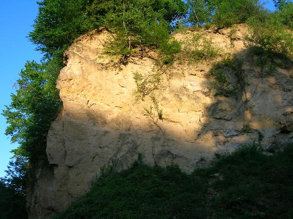
Ein Steilhang des Dobergs
By mining, traces of the flora and in particular of the fauna of the Oligocene were laid open (for example mussels, snails, sea urchins, and fishes). The Oligocene is a geologic epoch of the Tertiary period and extends from about 33.9 million to 23 million years before the present. Because of the eminent discoveries of fossils (amongst others a sea cow (Anomotherium langewieschei) and the cranium of a toothedwhale(Eosqualodon langewieschei )) by Friedrich Langewiesche in 1911 and 1912, the mining of marl was abruptly stopped.
Since that time, this place is ofparticular importancefor geologists, and it is known beyond the frontiers of Germany.
The cranium of the toothedwhale became famous because of the best conservation of a fossil cranium of a whale on the northern hemisphere. This animal lived approximately 27-28 million years ago.
But the real attraction, which was found in the Doberg, is the well-preserved, fossil skeleton of a sea cow. It lived at the same time as the toothed whale, maybe 2 million years later.
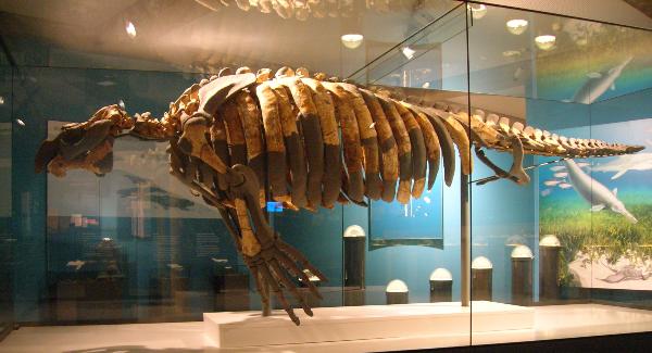
Das Skelett der Seekuh im Dobergmuseum
The today fixed stones of sand, lime and argil deposited in nearly horizontal stratums in the ocean or land-based. Based on the systematic recording and ascertainment of the fossils which are covered in the stratums, it is possible to learn about the history of the erstwhile alive world.
When this area was covered by the primordial North Sea, palm trees, maidenhair trees, sequoias, bay, but also pasturages, birch trees, beech trees and oak trees could grow. Rhinoceroses, crocodiles, tortoises and hellbender could live here because the climatic conditions at that time were rather subtropical.
Today the Doberg still comprises old diposits of the complete Oligocene. Bünde possesses one of the most extensivereservoir north of the Alps.
The complete nature protection area of the Doberg is 47,86 hectares in size and since 1912 it is registered.
Personal digging for fossils and climbing up scarps is strictly forbidden to protect this beautiful nature protection area and its erstwhile 500 different animal species!! Today there live alone 85 different bee and wasp species.
Who wants to know more about the Doberg or who wants to see the sea cow in real can visit the museum of Bünde (N 52° 11.718’ E 8° 34.923’)
Persons who answered correctly and who handled these three points are allowed to log this cache.
Point 1: In which year, the Doberg was defined as a place, where (worldwide) the periods of the Oligocene were constituted?
Point 2: What color are on the card, the rocks of the Jurassic period?
Point 3: Take a photo of you in front of the high hill behind the informationboards.
Please send us the answers via email.
 Punti addizionali
  Conversione coordinate
|
N 52° 11.064' E 008° 36.686' |
|||
|
N 52° 11.060' E 008° 36.860' |
Hier vor dem Felsen das Foto machen. Take your picture infront of this rock. |
||
|
N 52° 11.055' E 008° 36.690' |
Informationstafeln Information boards |


 Waypoints addizionali possono rendere la ricerca più semplice, per esempio con le indicazioni di un parcheggio o del punto di partenza di un sentiero. I waypoints sono inclusi nei file GPX e inviati al dispositivo GPS.
![]() Utilità
Utilità
![]() Questa geocache è probabilmente situata all'interno di un'area naturale protetta! Per favore, vedi qui per ulteriori informazioni.
Questa geocache è probabilmente situata all'interno di un'area naturale protetta! Per favore, vedi qui per ulteriori informazioni.
Naturschutzgebiet
NSG Doberg (Informazioni)
 Cerca geocache vicine:
tutte -
ricercabile -
stesso tipo
Cerca geocache vicine:
tutte -
ricercabile -
stesso tipo
 Scarica come file:
GPX -
LOC -
KML -
OV2 -
OVL -
TXT -
QR-Code
Scaricando questo file accetti i nostri termini di utilizzo e la Licenza dati.
Scarica come file:
GPX -
LOC -
KML -
OV2 -
OVL -
TXT -
QR-Code
Scaricando questo file accetti i nostri termini di utilizzo e la Licenza dati.
![]() Log per Die Seekuh [Earthcache]
Log per Die Seekuh [Earthcache]
![]() 4x
4x
![]() 0x
0x
![]() 1x
1x
 11. gennaio 2022
Maedchen100
ha trovato la geocache
11. gennaio 2022
Maedchen100
ha trovato la geocache
Heute
haben wir einen Spaziergang hier am Doberg unternommen. Der Earthcache
konnte dabei gut erledigt werden. Die Informationen wurden gesammelt und
nach dem Versenden der E-Mail kam umgehend die Logerlaubnis ![]() .
.
Vielen Dank an Kakaocacher für diesen interessanten Earthcache! 
Photo EC: Die Seekuh

18. luglio 2020
raffo32
ha trovato la geocache
Eine 51 Kilometer Radtour, zunächst musste ich noch 2 meiner Caches warten - dann ging es ins Zielgebiet das sich sehr erweitete. Zunächst Pödinghausen, dann nach Bünde.
**Zum Cache**: Diesen hier immer übersehen, war doch einfach zu beantworten. Lediglich das Foto von hinten wäre wegen der Vegetation nun GAR NICHTS geworden, daher passend hingestellt
 28. maggio 2020
Kakaocacher
ha scritto una nota
28. maggio 2020
Kakaocacher
ha scritto una nota
Da ich all meine aktiven GC Caches auch bei OC eingepflegt habe, kann jeder, der diesen Cache bereits in den vergangenen Jahren bei GC gefunden hat, gerne auch hier bei OC loggen, ohne, dass eine erneute Antwort-Mail notwendig ist...
last modified on 29. maggio 2020
04. agosto 2017
CADS11
ha trovato la geocache
Interessante Gegend hier. Da hat dich der Abstecher gelohnt.
Danke für die Ausarbeitung.
CADS11
27. luglio 2013
angro
ha trovato la geocache
17:15 Uhr. Bei einem Besuch in meiner alten Heimat habe ich den mich begleitenden Geocoins und Tackables einmal den Doberg gezeigt und diese Earthcache gelöst.
TFTC,
angro