| Idioma: |


|
País: |


Birds in the sky - VOR GRZ
Point near a building in the middle of nowhere (PNABITMON)
por aj-gps
 Austria > Steiermark > Graz
|
|
||||
|
|||||


 Tamaño: micro
 Estado: disponible
 Ocultos en: 25. marzo 2009
 También en la categoría de:
  13 encuentran
 0 no encontrado
 0 Notas
 4 Maintenance logs
 1 Watcher
 0 Ignorado
 353 Visitas
 2
2 

![]() Descripción
English
(Inglés)
Descripción
English
(Inglés)
June 2015: The cache is no longer located near the building in question as there have been a few issues in the past with cachers driving to the cache location or climbing fences. If you are interested in the building please walk to waypoint "VORGRZ".
Please bring your own pen! It's not necessary to climb over fences.
People who are just interested in a quick found-point can stop reading now.
I told you to stop reading!!
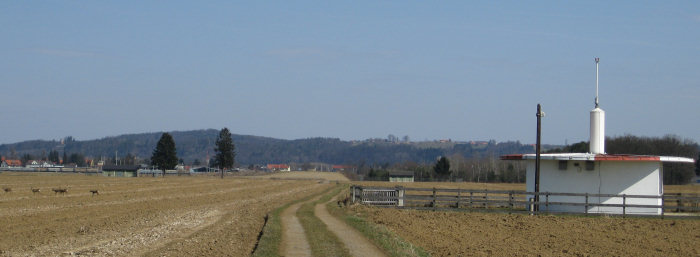
Anyway.. on a field a bit south of the main runway of the airport Graz-Thalerhof (GRZ/LOWG) you'll find a rather unimpressive building. No high fences, no barbed wire.. just a white sign bearing the logo of AustroControl - the company responsible for managing Austrian air traffic - and a note that this building is used for air traffic safety purposes.
But what's the purpose of this building and what makes it a bit more interesting than the usual buildings found on nearby fields? (Okay, maybe the antenna with the red lights.. but did I mention the ammunition depots of the Austrian military northeast of this location that aren't all that usual as well? - "Pulverturmstrasse", nomen est omen)
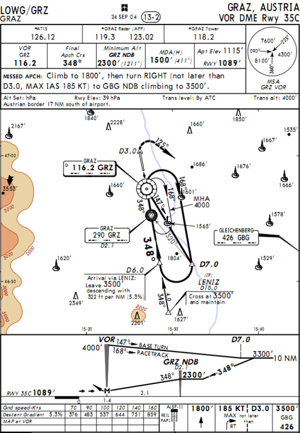
The "code name" of this special building is "VOR-DME GRZ" - short for "VHF Omni-directional Radio Range (with Distance measuring equipment)", but just describing it as a "radio beacon" might make things a bit more clear.
Still, what does this have to do with "birds in the sky"?
Well, contrary to geocachers airplane pilots are usually not relying on GPS signals for determinating their position but on measurements based on radio signals sent from ground stations. These stations are commonly referred to as navigational aids, short "navaids" (also in nautical travel). There are basically two different types of ground stations used for this purpose, non-directional beacons (NDB) and VOR.
A NDB is more or less an antenna that periodically sends a radio signal together with a morse code. An automatic direction finder (ADF) is then used on board of the plane to display the bearing towards the NDB.
VORs are much like NDBs, but also include a directional amplitude-modulated signal that rotates 30 times per second. Older systems really used a rotating antenna for this purpose while current systems can do that electronically without any moving parts. VORs are much more reliable and accurate that NDBs. When receiving signals of two VOR it's possible to determine an exact position (cross bearing). That's where the third acronym comes into play - DME, distance measuring equipment. An aircraft sends a series of pulse-pairs towards the DME which replies after a short delay. After locking in on the signal exact runtime measurements are possible which can be used to calculate the distance between the aircraft and the DME.
With VOR and DME a single ground station is enough for position determination.
In Austria there are 17 NDB and 11 VOR-DME stations. Graz has both a NDB (290kHz; at approx. N46°55.233 E015°27.533) and a VOR (116.2MHz). The next NDB is at Gleichenberg (GBG; 426kHz).
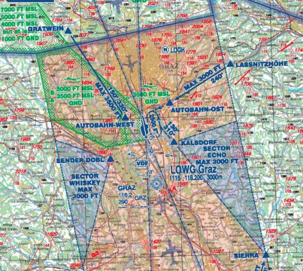
Of course both VOR and NDB are marked on flight charts and also used during approach together with several other interesting installations.
Oh, and even if you're not interested in technology: Maybe you'll also spot some deer (see header picture) or wild rabbits near the location. It would be quite nice if the motorway wouldn't be that noisy..
Corrections are welcome.
![]() Ayuda adicional
Ayuda adicional
![]() Descripción
Descripción
[EN:] Srapr
[DE:] Mnha
A|B|C|D|E|F|G|H|I|J|K|L|M
N|O|P|Q|R|S|T|U|V|W|X|Y|Z
![]() Utilidades
Utilidades
 Buscar geocaches en las inmediaciones:
todo -
búsqueda -
mismo tipo
Buscar geocaches en las inmediaciones:
todo -
búsqueda -
mismo tipo
 Descargar como archivo:
GPX -
LOC -
KML -
OV2 -
OVL -
TXT -
QR-Code
Descargar como archivo:
GPX -
LOC -
KML -
OV2 -
OVL -
TXT -
QR-Code
 Al descargar este archivo, aceptas nuestros terminos de uso y Licencia de Datos.
![]() Log de entrada por Birds in the sky - VOR GRZ
Log de entrada por Birds in the sky - VOR GRZ
![]() 13x
13x
![]() 0x
0x
![]() 0x
0x
![]() 4x
4x


 15. agosto 2022
Zoidberg73
ha encontrado el geocache
15. agosto 2022
Zoidberg73
ha encontrado el geocache
Am heutigen Feiertag ging es Richtung Kaiserwald. Im Rahmen dessen konnten wir zusätzlich weiteren Caches in der Umgebung einen Besuch abstatten...
Anmerkung zu diesem Cache: Dank des Hinweises konnte die Dose rasch entdeckt werden; Logging war problemlos möglich. Danke für die ausführlichen Erklärungen zu diesem interessanten Objekt!
TFTC an aj-gps für Idee, Realisierung und Wartung dieses Caches!
10. marzo 2018
KVH12
ha encontrado el geocache
Hab ihn TftC
 17. octubre 2017
aj-gps
has maintained the cache
17. octubre 2017
aj-gps
has maintained the cache
Enjoy
![]() New coordinates:
N 46° 57.286' E 015° 26.686',
moved by 20 meters
New coordinates:
N 46° 57.286' E 015° 26.686',
moved by 20 meters
 08. junio 2017
aj-gps
has disabled the cache
08. junio 2017
aj-gps
has disabled the cache
Cache container might be missing.