| Language: |


|
Country: |












 Romania > Sud-Est > Buzău
|
|
||||
|
|||||


 Size: no container
 Status: Available
 Hidden on: 12 October 2013
 Listing: https://opencaching.de/OC1065D
 Also listed at:
  3 Found
 0 Not found
 0 Notes
 0 Watchers
 0 Ignorers
 143 Page visits
 3
3 

 Cache lists
| Infrastructure |

|
| Time |

|
 Description
![[RO]](https://s3.amazonaws.com/gs-geo-images/15da3ee9-51aa-495f-9df5-51b998cf3b4e_l.png) Acest Pământ-cache vă va arăta vulcanii noroioși de la Berca. În România se cunosc mai multe locuri cu vulcani noroioși, cel din valea Berca-Arbănasi fiind cel mai extins [1]. La Berca o suprafață de 30 km2 în jurul vulcanilor noroioși a fost declarată rezervație naturală în 1924. Aici există două zone învecinate cu vulcani noroioși și anume Pâclele Mari (coordonate de mai sus) și Pâclele Mici (N 45 ° 20.350 E 026 ° 42.500).
Acest Pământ-cache vă va arăta vulcanii noroioși de la Berca. În România se cunosc mai multe locuri cu vulcani noroioși, cel din valea Berca-Arbănasi fiind cel mai extins [1]. La Berca o suprafață de 30 km2 în jurul vulcanilor noroioși a fost declarată rezervație naturală în 1924. Aici există două zone învecinate cu vulcani noroioși și anume Pâclele Mari (coordonate de mai sus) și Pâclele Mici (N 45 ° 20.350 E 026 ° 42.500).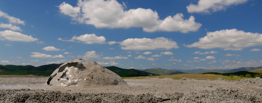 Vulcanii noroioși sunt formați prin "erupții" lente sau bruște de gaze naturale - în principal metan - care împing noroi, ape subterane și, uneori, petrol, la suprafață. Prin uscarea noroiului apar structuri asemănătoare conurilor vulcanice cu o înălțime de cîțiva metri. [2]. Se estimează [3] că vulcanii noroioși de la Berca emit aproximativ 1200 de tone de metan pe an, un gaz cu un puternic efect de seră. Gazul provine de la o adâncime de circa 3 km.
Din punct de vedere geologic, pot fi distinse două tipuri de vulcani noroioși. Un tip este asociat cu activitatea vulcanică reală, celălalt nu [1]. Vulcanii noroioși de la Berca aparțin ultimului tip. Vulcanii noroioși sunt adesea asociați fie cu regiuni geodinamic active (falii) fie cu prezența depozitelor de petrol și gaze naturale [1], sau cu ambele cum este cazul aici. Prezența unor depozite de gaze naturale în regiunea Buzăului este atestată și de un alt fenomen interesant, focuri vii.
Pentru a întregistra (log) acest cache, vă rugăm să răspundeți la întrebările de mai jos și să trimiteți răspunsurile la adresa de e-mail din profilul nostru:
1) Noroiul provenit din vulcanii este fierbinte sau rece, și de ce?
2) Cât de multe "cratere" active puteți identifica?
3) Estimați înălțimea aproximativă a celui mai înalt vulcan noroios - nu este nevoie de un răspuns precis, faceți doar o aproximație.
4) Credeți că răspunsurile la alineatul (2) și (3), vor fi la fel dacă vă întoarceți cam peste an, și de ce?
5) (opțional) Încărcați o imagine a voastră și / sau a GPS-ul vostru când înregistrați cache-ul
Puteți înregistra cache-ul de îndată ce ați trimis răspunsurile, nu este nevoie să așteptați permisiunea noastră. Dacă există probleme cu răspunsurile voastre, vă vom contacta...
![[EN]](https://s3.amazonaws.com/gs-geo-images/8076b85b-38d1-40f9-9e1f-9c73f8e73bb2_l.png) This Earth Cache will show you the Berca mud volcanoes. Several sites with mud volcanoes are known in Romania, with those here in the Berca-Arbanasc valley being the largest [1]. An area of 30 km2 surrounding the Berca mud volcanoes was declared a nature reserve in 1924. Here, two sites exist in close proximity, Paclele Mari (above coordinates) and Paclele Mici (N 45° 20.350 E 026° 42.500).
This Earth Cache will show you the Berca mud volcanoes. Several sites with mud volcanoes are known in Romania, with those here in the Berca-Arbanasc valley being the largest [1]. An area of 30 km2 surrounding the Berca mud volcanoes was declared a nature reserve in 1924. Here, two sites exist in close proximity, Paclele Mari (above coordinates) and Paclele Mici (N 45° 20.350 E 026° 42.500).
Geologically, two types of mud volcanoes can be distinguished. One type is associated with true volcanic activity, the other type is not [1]. The Berca mud volcanoes belong to the latter type. Mud volcanoes are often associated with either geodynamically active regions or the presence of oil and gas deposits [1], or both as is the case here.
In order to log this cache, please answer the questions below and send them to the e-mail adress in our profile:
1) Is the mud ejected from the volcanoes hot or cold, and why?
2) How many active "craters" can you identify?
3) Estimate the approximate height of the highest mud volcano - there is no need to be precise here, just make a guess.
4) Do you think the answers to (2) and (3) will be the same if you come back in a year or so, and why?
5) (optional) Upload a picture of yourself and/or your GPS with your log
You can log the cache as soon as you have sent the answers, there is no need to wait for a log permission. If there are any problems with your answers we will get in touch ...
Sources:
[1] V.N. Kholodov, Lithology and Mineral Resources 37(2002)197; Mud Volcanoes, Their Distribution Regularities and Genesis: 1.
[2] Wikipedia - Berca Mud Volcanoes
[3] G. Etiope et al., Terra Nova 16(2004)179; Gas Flux to the Atmosphere from Mud Volcanoes in Eastern Romania
Photos & video: own work; flags: public domain
 Utilities
 Show cache recommendations from users that recommended this geocache: all
 Search geocaches nearby:
all -
searchable -
same type
Search geocaches nearby:
all -
searchable -
same type
 Download as file:
GPX -
LOC -
KML -
OV2 -
OVL -
TXT -
QR-Code
Download as file:
GPX -
LOC -
KML -
OV2 -
OVL -
TXT -
QR-Code
 When downloading this file, you accept our terms of use and Data license.
 Log entries for Berca Mud Volcanoes
 3x
3x
 0x
0x
 0x
0x
13 September 2026, 19:46
trassolix
found the geocache
🇩🇪 Mit dem Womo wollen wir der Donau von der Quelle flussabwärts folgen und viele interessante Orte kennenlernen. Wir wissen nicht, ob wir es in der uns zur Verfügung stehenden Zeit bis zum Delta schaffen. Da es gut aussieht machen wir heute einen Umweg und fahren zu den Schlammvulkanen nach Berca.
Ist schon etwas Anderes als ich in Neuseeland gesehen habe. Etwas kleiner und auch anderen Ursprungs. Aber sehr interessant.
dfdc
Trassolix
Fund: 860
PS. Antwort ist an den GC Account gegangen EC
Berca Mud Volcanoes

24 August 2026, 11:14
MiriDeLuxe
found the geocache
Mit dem lieben Herrn H.E.R.A. unterwegs in Wald und Flur und Wasser und Stadt und Burg und Schloss...
Das Foto konnte erfolgreich geknipst und die Antworten ermittelt werden 🤗 🤩
Antworten wurden mit GC4HHYH gesendet.
Dankeschön für's Herführen, Legen und Pflegen sagt mit lieben Grüßen MiriDeLuxe
Bild

 24 August 2026, 11:10
H.E.R.A.
found the geocache
24 August 2026, 11:10
H.E.R.A.
found the geocache
Mit der lieben MiriDeLuxe im Urlaub Richtung Südosteuropa.
Unsere Reise durch Rumänien geht weiter!
Auf dem Weg zu den Schlammvulkanen.
Und da sind wir!
TFTC ... die Dose, das Herführen, das Legen und Pflegen oder das Event ... mit vielen Grüßen ... H.E.R.A. 👋
Bild
