| Lingua: |


|
Nazione: |


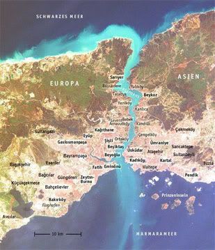
Bosporus - Bogaziçi
Istanbul, the only city in the world on two continents Europe and Asia, both sides of the Bosporus.
di Lady Biene
 Germania
|
|
||||
|
|||||


 Dimensioni: nessun contenitore
 Stato: disponibile
 Nascosta il: 17. maggio 2010
 Pubblicata anche su:
  16 trovata
 1 non trovata
 0 Note
 1 Osservatore
 1 Ignorata
 1363 Pagina visite
 8
8 

 Cache lists
| Infrastrutture |


|
| Waypoints |

|
| Comune |

|
| Tempo |

|
| Stagionale |

|
| Persone |

|
![]() Descrizione
Deutsch
· English
(Inglese)
Descrizione
Deutsch
· English
(Inglese)
The Bosporus
The Bosporus is the connection between the Marmara Sea in the south and the Black Sea in the north. It is a part of the border between Europe and Asia. On both sides of the strait the city of Istanbul applies. At the southern end lies the Golden Horn, the harbour bay of the former capital of the osmanian empire, one of the biggest physical harbours of the world.
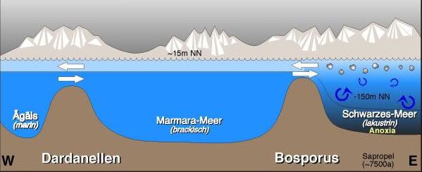
About the origin of the Bosporus there are two theories about which the scientists argue until today.
 |
The biblical flood Following the theory of two American geologists, the biblical flood has its origin at the Bosporus. Place of the flood was the Black Sea that had dried up after the last ice age to a salty brackish water lake. A connection with the oceans did not exist. 7500 years ago the rock dam suddenly broke, which had held back the glaze floods in the Mediterranean Sea. The water flowed out years with high pressure through the rock tube between Asia and Europe, making the level of the Black Sea rise by 15 centimetres each day. A leveling of the seas resulted. The people fled before the floods – the event engraved so deeply into the collective memory, that the biblical flood myth took its origin. Gradual increase Another theory claims, the rivers Danube, Don and Dnjepr poured into the Black Sea. They all led large amounts of melt water. The sea rose and slowly ran over, resulting in a flood. Nevertheless, this was far less spectacular than in the first scenario. During about thousand years the water about the Bosporus threshold flows out by a deep gulch in the just twenty metre deeper situated Marmara Sea. |
|
Two currents So conflicting as the theories of its history, are the two currents are of the Bosporus. One flows in the surface and a weaker undercurrent in about 40 metre depth. The upper stream comes from the Black Sea. It is less salty and - hence - lighter. It flows to the lower situated Marmarameer. The unterstream flows with its saltier water in opposite direction. |
 |
 |
Naming Bosporus means translated "cattle ford” or “cow ford" - a name with mythological origin. God's father Zeus fell in love with the nice Io, one of the priests of his wife Hera. He kidnapped her and transformed her into a cow to hide her from his jealous spouse. But Hera noticed the cheat and sent a gadfly after Io, who escaped in her animal figure. On the escape, the beauty crossed the ford between Asia and Europe, which, from now on, got its name. |
Log-Conditions:
-
Answer the following questions and send the answers in a mail. You do not have to wait for admittance, if something is wrong, I’ll contact you.
-
Take a photo of you or your GPS at a point with a scenic view over the Bosporus. The given coordinates lead to the beautiful terrace in the courtyard of the Topkapi-palace. If you do not want to pay the access fee, you may also answer the questions from the Kennedy Cd.
Questions:
-
Look to the asian side oft the Bosporus. Guess how far it is to the other side at this place. By the way: The Bosporus is – on it’s thinest spot about 700 meters wide and about 2.5 kilometer at it’s widest.
-
How many mountain peaks do you see on the other side? Describe them.
-
Take some time and watch the ships passing by – and also those waiting for passage. What do you think: How many ships pass the straight each day?
-
In which direction the wind has to blow, to change the surface flow of the Bosporus?
-
What are the names oft he two american geologists setting up the biblical-flood-theory?
![]() Utilità
Utilità
 Visualizza le raccomandazioni degli utenti che hanno raccomandato questa geocache: all
 Cerca geocache vicine:
tutte -
ricercabile -
stesso tipo
Cerca geocache vicine:
tutte -
ricercabile -
stesso tipo
 Scarica come file:
GPX -
LOC -
KML -
OV2 -
OVL -
TXT -
QR-Code
Scarica come file:
GPX -
LOC -
KML -
OV2 -
OVL -
TXT -
QR-Code
 Scaricando questo file accetti i nostri termini di utilizzo e la Licenza dati.
![]() Log per Bosporus - Bogaziçi
Log per Bosporus - Bogaziçi
![]() 16x
16x
![]() 1x
1x
![]() 0x
0x
 30. settembre 2023
Geist13
ha trovato la geocache
30. settembre 2023
Geist13
ha trovato la geocache
Sehr schöner Cache. Danke fürs Legen und Pflegen. TFTC
03. aprile 2018, 16:57
pferseeer
ha trovato la geocache
Cache Nummer 500! Danke fürs Zeigen und die Infos. Pferseeer mit Luna-Fortuna.
13. giugno 2015
Triariel
ha trovato la geocache
Bei einer Führung durch den Topkapi-Palast am GZ eine kleine Pause gemacht und dabei den schönen Ausblick genossen.
Danke für die vielen Informationen und für das Zeigen.
Am Aussichtspunkt

22. marzo 2015
J_682
ha trovato la geocache
The view from the palace is great. Thanks a lot for the background information on the Bosporous especially on the theory of the biblical flood. Very interesting.
For my log picture please see gc log.
02. novembre 2014
D-Buddi
ha trovato la geocache
Wir hätten fast vergessen die Antworten zu ermitteln so schön war die Aussicht hier oben, Istanbul ist schon eine Tolle Metropole!
No Trade
MfG Jörg