| Idioma: |


|
País: |


![]()
 Alemania > Rheinland-Pfalz > Mayen-Koblenz
¡Atención! Este geocache es "archivado"! No es un contenedor físico a las coordenadas especificadas (o los que tienen que determinar). ¡El interés del lugar no es necesariamente la búsqueda!
|
|
||||
|
|||||


 Tamaño: sin contenedor
 Estado:
  Tiempo requerido: 0:30 h
 Ocultos en: 18. enero 2010
 También en la categoría de:
  11 encuentran
 0 no encontrado
 0 Notas
 1 Maintenance log
 1 Watcher
 0 Ignorado
 250 Visitas
 5
5 

| Peligroso |


|
| Infraestructura |

|
| Ruta |

|
| Tiempo |

|
| Estacionales |

|
![]() Descripción
Deutsch
(Alemán)
Descripción
Deutsch
(Alemán)
Deutsch:
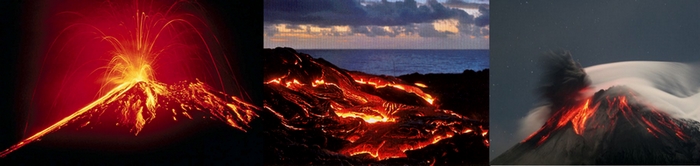
Der Nastberg
Der Nastberg ist ein Schlackenkegel. Während der ersten
Ausbruchphase werden phreatomagmatische Eruptionen durch den
Kontakt von aufsteigendem Magma mit Wasser ausgelöst.
Vulkanite und ein hoher Gesteinsanteil des Grundgebirges werden aus
dem Einbruchskrater geschleudert. Um das Ausbruchszentrum, das sich
mit jeder Eruption tiefer ins Grundgebirge verlagert, wächst
ein niedriger Ringwall, auch Tuffring genannt. Die tiefen Krater
dieser Vulkanform füllen sich mit der Zeit mit Wasser und
werden dann als Maar bezeichnet.
In der zweiten, magmatischen Eruptionsphase wird gasreiches
Magma in großen und kleinen Lavafetzen aus dem Schlot
geschleudert. Die Lavafetzen verschweißen entweder noch
glühend auf dem Krater- und Außenwall oder fallen zu
Schlacken abgekühlt zu Boden. Um den Schlot baut sich ein
Schlackenwall auf, der in einigen Tagen eine Höhe von mehr als
100 Metern erreichen kann. Gasarmes Magma steigt oftmals im Verlauf
der Eruption im Schlot auf und verfüllt den Krater oder
fließt als Lava über den Kraterrand ab. Dringt die Lava
durch den Schlackenwall, wird dieser oftmals
zerstört.
Aufgaben:
Folge dem Rundweg vom Parkplatz durch den östlichen Zugang links durch die nördliche Grube, dann weiter Richtung Gipfel. Auf dem Rückweg kannst du an dem Abzweig in die nördliche Grube geradeaus zurück zum Parkplatz gehen. Auf diesem Weg kommst du an 16 Schautafeln über den Nastberg vorbei. Auf diesen Tafeln stehen die Antworten zu folgenden Fragen:
1. Welche Größe haben Lapillischlacken?
2. Wie groß ist die Sprengkraft der phreatomagmatischen Eruptionen?
3. Was bezeichnet der Ausdruck „Krotzen“?
Sende mir die Antworten vor dem Loggen per eMail zu. Nach
Logfreigabe füge deinem Log bitte ein Bild von dir vor dem
Gipfelkreuz (siehe Beispielfoto) hinzu.
English:
The Nastberg
The mountain Nastberg is a slag cone. During the first outbreak
phase phreatomagmatic eruptions are released by the contact of
water with climbing up magma. Vulkanite and a high rock portion of
the basement are flung from the burglary crater. Around the
outbreak center which shifts deeper in the basement with every
eruption a low ring embankment grows, called also tuff ring. The
deep craters of this volcano form and filled up with water then are
called Maar.
In the second magmatic eruption phase magma rich in gas is flung
in big and small lava scrap from the chimney. The lava scraps weld
together either still glowing on the crater embankment and outside
embankment, or fall to the ground cooled as slags. Around the
chimney a slag embankment is based which can reach a height of more
than 100 meters in some days. Low-gas magma often climbs up in the
course of the eruption in the chimney and fills the crater or runs
off as a lava above the crater edge. If the lava penetrates the
slag embankment, this often is destroyed.
Questions:
Follow the flatly from the parking site by the eastern access on the left by the northern pit, then of wide direction to the summit. On the way back you can go on straight ahead back to the parking site at the northern pit. On this way you will past by 16 display-boards with descriptions to the area. On these boards you will find the answers to the following questions:
1. Which size do "Lapillischlacken"
have?
2. How big is the explosive force of the phreatomagmatic
eruptions?
3. What is the meaning of the expression "Krotzen"?
Please send me the answers with eMail. After my response please log your visit with a picture of you before the summit cross (see example photo).
![]() Imagenes
Imagenes
![]() Utilidades
Utilidades
![]() ¡Este geocache está probablemente situado dentro de una zona de protección de la naturaleza! Mira aqui para obtener más información, por favor.
¡Este geocache está probablemente situado dentro de una zona de protección de la naturaleza! Mira aqui para obtener más información, por favor.
Naturschutzgebiet
Nastberg (Información)
Este geocache está probablemente en las siguientes áreas protegidas (Info): Landschaftsschutzgebiet Rhein-Ahr-Eifel (Información), Vogelschutzgebiet Unteres Mittelrheingebiet (Información)
 Mostrar recomendaciones de los usuarios que recomiendan este geocaché: all
 Buscar geocaches en las inmediaciones:
todo -
búsqueda -
mismo tipo
Buscar geocaches en las inmediaciones:
todo -
búsqueda -
mismo tipo
 Descargar como archivo:
GPX -
LOC -
KML -
OV2 -
OVL -
TXT -
QR-Code
Descargar como archivo:
GPX -
LOC -
KML -
OV2 -
OVL -
TXT -
QR-Code
 Al descargar este archivo, aceptas nuestros terminos de uso y Licencia de Datos.
![]() Log de entrada por Nastberg
Log de entrada por Nastberg
![]() 11x
11x
![]() 0x
0x
![]() 0x
0x
![]() 1x
1x
 08. julio 2023, 15:55
danspataru
ha encontrado el geocache
08. julio 2023, 15:55
danspataru
ha encontrado el geocache
Den Gipfel des erloschenen Vulkans bestiegen. Ein Kreuz und eine schöne Aussicht gab es dort zu bewundern. Auf dem Weg hinauf und wieder runter gab es etwas zu lernen, vor allem was Krotzen sind. Ein sehr interessant klingender Name. Krotzen, rotzen, Fotzen ... war da sofort in meinem Kopf. Ich danke für den tollen und lehrreichen EarthCache!
Imagen para el log de entradadanspataru

krotzen

06. junio 2020
filser1
ha encontrado el geocache
Heute habe ich den Nastberg bestiegen. Eine tolle Aussicht und imposante Gesteinsformationen. Natürlich wieder was gelernt. T4TC
31. octubre 2016
Lettertrolline
ha encontrado el geocache
Gemeinsam mit xtqx1 besuchte ich den Nastberg in unserem Eifelurlaub. Ein wirklich sehr netter Lehrpfad mit vielen interessanten Informationen und einem tollen Pfad drumrum, mittendrin und hoch hinauf. Dort wurden wir mit suuuper Aussichten und noch mehr Infos belohnt.
Vielen Dank für den Cache sagt
Lettertrolline
31. octubre 2016
xtqx1
ha encontrado el geocache
Ein interessanter Ort an den es Lettertrolline und mich heute verschlug.
Wieder einmal konnten wir unser Wissen um die vulkanische Vergangenheit dieser Region ausweiten und vertiefen.
Danke für den Cache,
xtqx1
22. diciembre 2013
Koblenzer
ha encontrado el geocache
Interessante Gegend mit Aussicht am Gipfelkreuz, welches wir gegen 16 Uhr erreichten. Danke für den Cache!